Strzegowo geodata
Strzegowo (Mazovia) is a seat of a third-order administrative division; located in Poland in Europe/Warsaw (GMT+2) time zone. With population of 2,000 people, there are 1469 cities with bigger population in this country. Compared to other cities in Poland, 82.3% of cities are located further ↓South; 62.3% of cities are located further ←West and 76% of cities have higher elevation than Strzegowo. Note1


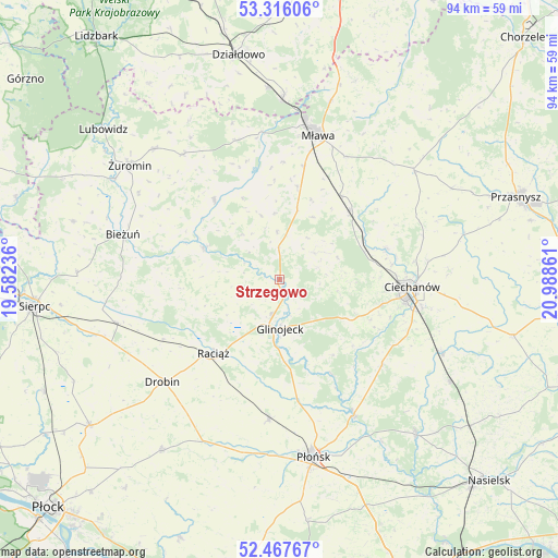
Strzegowo GPS coordinates[2]
52° 53' 38.184" North, 20° 17' 7.728" East
| Map corner | latitude | longitude |
|---|---|---|
| Upper-left | 53.31606°, | 19.58236° |
| Center: | 52.89394°, | 20.28548° |
| Lower-right: | 52.46767°, | 20.98861° |
| Map W x H: | 94.3×94.3 km | = 58.6×58.6mi |
| max Lat: | 54.83135° ⇑17.7% North |
| Strzegowo: | 52.89394° |
| min Lat: | ⇓82.3% South 49.21328° |
| min Long | Strzegowo | max Long |
| 14.20249° | 20.28548° | 24.03723° |
| W 62.3%⇐ | ⇒37.7% E |
Elevation
Elevation of Strzegowo is 108 m = 354 ft, and this is 83.4 m = 274 ft below average elevation for this country.
| Max E: |
974 m = 3196 ft | 76% |
| Avg. | 191.4 m = 628 ft | |
| Strzegowo | 108 m = 354 ft | |
Min E: |
-3 m = -10 ft | 24% |
See also: Poland elevation on elevation.city.
Geographical zone
Strzegowo is located in North temperate zone (between Tropic of Cancer and the Arctic Circle). Distance of this North polar circle is 1519.9 km =944.4 mi to North.| Distance of | km | miles | from Strzegowo |
|---|---|---|---|
| North Pole | 4125.8 | 2563.7 | to North |
| Arctic Circle | 1519.9 | 944.4 | to North |
| Tropic Cancer | 3275.3 | 2035.2 | to South |
| Equator | 5881.3 | 3654.5 | to South |


Nearby cities:
15 places around Strzegowo: (largest is in red/bold)
• Baboszewo
23.8 km =14.8 mi,  184°
184°
• Ciechanów
22.5 km =14 mi,  93°
93°
• Glinojeck
8.3 km =5.2 mi, 176°
• Lipowiec Kościelny
24.5 km =15.2 mi,  342°
342°
• Mława
25.2 km =15.7 mi,  15°
15°
• Ojrzeń
22.4 km =13.9 mi,  129°
129°
• Raciąż
16.8 km =10.4 mi,  222°
222°
• Radzanów
14 km =8.7 mi,  292°
292°
• Regimin
18.7 km =11.6 mi,  73°
73°
• Siemiątkowo
17.3 km =10.7 mi,  265°
265°
• Sochocin
26.2 km =16.3 mi,  151°
151°
• Stupsk
17.5 km =10.9 mi,  35°
35°
• Szreńsk
17.2 km =10.7 mi,  320°
320°
• Szydłowo
23.5 km =14.6 mi,  28°
28°
• Wiśniewo
19.4 km =12.1 mi,  12°
12°
Sources, notices
• [Note1] Compared only with cities in Poland existing in our database
• [Src1] Map data: © OpenStreetMap contributors (CC-BY-SA)
• [Src2] Other city data from geonames.org with taken over terms of usage.
• [Src3] Geographical zone / Annual Mean Temperature by Robert A. Rohde @ Wikipedia
