Straszydle geodata
Straszydle (Subcarpathian) is a populated place; located in Poland in Europe/Warsaw (GMT+2) time zone. With population of 2,077 people, there are 1440 cities with bigger population in this country. Compared to other cities in Poland, 87.5% of cities are located further ↑North; 84.7% of cities are located further ←West and 77.9% of cities have lower elevation than Straszydle. Note1


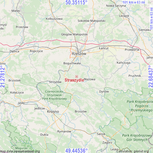
Straszydle GPS coordinates[2]
49° 54' 1.368" North, 21° 58' 52.464" East
| Map corner | latitude | longitude |
|---|---|---|
| Upper-left | 50.35115°, | 21.27812° |
| Center: | 49.90038°, | 21.98124° |
| Lower-right: | 49.44536°, | 22.68437° |
| Map W x H: | 100.7×100.7 km | = 62.6×62.6mi |
| max Lat: | 54.83135° ⇑87.5% North |
| Straszydle: | 49.90038° |
| min Lat: | ⇓12.5% South 49.21328° |
| min Long | Straszydle | max Long |
| 14.20249° | 21.98124° | 24.03723° |
| W 84.7%⇐ | ⇒15.3% E |
Elevation
Elevation of Straszydle is 257 m = 843 ft, and this is 65.6 m = 215 ft above average elevation for this country.
| Max E: |
974 m = 3196 ft | 22.1% |
| Straszydle | 257 m 843 ft | |
| Avg. | 191.4 m = 628 ft | |
Min E: |
-3 m = -10 ft | 77.9% |
See also: Poland elevation on elevation.city.
Geographical zone
Straszydle is located in North temperate zone (between Tropic of Cancer and the Arctic Circle). Distance of this North polar circle is 1852.8 km =1151.3 mi to North.| Distance of | km | miles | from Straszydle |
|---|---|---|---|
| North Pole | 4458.7 | 2770.5 | to North |
| Arctic Circle | 1852.8 | 1151.3 | to North |
| Tropic Cancer | 2942.5 | 1828.4 | to South |
| Equator | 5548.4 | 3447.6 | to South |


Nearby cities:
15 places around Straszydle: (largest is in red/bold)
• Babica
8.8 km =5.5 mi,  295°
295°
• Białka
5.1 km =3.2 mi,  130°
130°
• Boguchwała
9.7 km =6 mi,  344°
344°
• Błażowa
8.7 km =5.4 mi,  101°
101°
• Gwoźnica Górna
8.1 km =5 mi,  171°
171°
• Jawornik
8.7 km =5.4 mi,  226°
226°
• Konieczkowa
7.5 km =4.7 mi,  210°
210°
• Lecka
3.4 km =2.1 mi,  136°
136°
• Lubenia
5.2 km =3.2 mi,  310°
310°
• Lutoryż
8.9 km =5.5 mi,  326°
326°
• Niebylec
7.4 km =4.6 mi, 228°
• Połomia
6.4 km =4 mi,  274°
274°
• Siedliska
6.4 km =4 mi, 337°
• Tyczyn
8 km =5 mi,  28°
28°
• Zarzecze
7.3 km =4.5 mi,  321°
321°
Sources, notices
• [Note1] Compared only with cities in Poland existing in our database
• [Src1] Map data: © OpenStreetMap contributors (CC-BY-SA)
• [Src2] Other city data from geonames.org with taken over terms of usage.
• [Src3] Geographical zone / Annual Mean Temperature by Robert A. Rohde @ Wikipedia
