Lecka geodata
Lecka (Subcarpathian) is a populated place; located in Poland in Europe/Warsaw (GMT+2) time zone. With population of 1,013 people, there are 2442 cities with bigger population in this country. Compared to other cities in Poland, 88.5% of cities are located further ↑North; 85% of cities are located further ←West and 88.9% of cities have lower elevation than Lecka. Note1


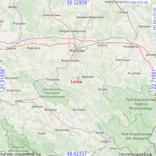
Lecka GPS coordinates[2]
49° 52' 42.96" North, 22° 0' 49.248" East
| Map corner | latitude | longitude |
|---|---|---|
| Upper-left | 50.32958°, | 21.31056° |
| Center: | 49.8786°, | 22.01368° |
| Lower-right: | 49.42337°, | 22.71681° |
| Map W x H: | 100.8×100.8 km | = 62.6×62.6mi |
| max Lat: | 54.83135° ⇑88.5% North |
| Lecka: | 49.8786° |
| min Lat: | ⇓11.5% South 49.21328° |
| min Long | Lecka | max Long |
| 14.20249° | 22.01368° | 24.03723° |
| W 85%⇐ | ⇒15% E |
Elevation
Elevation of Lecka is 316 m = 1037 ft, and this is 124.6 m = 409 ft above average elevation for this country.
| Max E: |
974 m = 3196 ft | 11.1% |
| Lecka | 316 m 1037 ft | |
| Avg. | 191.4 m = 628 ft | |
Min E: |
-3 m = -10 ft | 88.9% |
See also: Poland elevation on elevation.city.
Geographical zone
Lecka is located in North temperate zone (between Tropic of Cancer and the Arctic Circle). Distance of this North polar circle is 1855.2 km =1152.8 mi to North.| Distance of | km | miles | from Lecka |
|---|---|---|---|
| North Pole | 4461.1 | 2772 | to North |
| Arctic Circle | 1855.2 | 1152.8 | to North |
| Tropic Cancer | 2940.1 | 1826.9 | to South |
| Equator | 5546 | 3446.1 | to South |


Nearby cities:
15 places around Lecka: (largest is in red/bold)
• Białka
1.8 km =1.1 mi,  119°
119°
• Błażowa
6.3 km =3.9 mi,  83°
83°
• Domaradz
11.3 km =7 mi,  205°
205°
• Golcowa
11.9 km =7.4 mi,  176°
176°
• Gwoźnica Górna
5.8 km =3.6 mi,  191°
191°
• Jawornik
9.3 km =5.8 mi,  247°
247°
• Konieczkowa
7.4 km =4.6 mi,  236°
236°
• Lubenia
8.5 km =5.3 mi,  312°
312°
• Niebylec
8.3 km =5.2 mi, 252°
• Połomia
9.2 km =5.7 mi,  288°
288°
• Siedliska
9.6 km =6 mi,  330°
330°
• Straszydle
3.4 km =2.1 mi,  316°
316°
• Tyczyn
9.6 km =6 mi,  8°
8°
• Wesoła
10.7 km =6.6 mi,  144°
144°
• Zarzecze
10.6 km =6.6 mi, 319°
Sources, notices
• [Note1] Compared only with cities in Poland existing in our database
• [Src1] Map data: © OpenStreetMap contributors (CC-BY-SA)
• [Src2] Other city data from geonames.org with taken over terms of usage.
• [Src3] Geographical zone / Annual Mean Temperature by Robert A. Rohde @ Wikipedia
