Siedliska geodata
Siedliska (Subcarpathian) is a populated place; located in Poland in Europe/Warsaw (GMT+2) time zone. With population of 1,700 people, there are 1678 cities with bigger population in this country. Compared to other cities in Poland, 85.1% of cities are located further ↑North; 84.1% of cities are located further ←West and 63.3% of cities have lower elevation than Siedliska. Note1


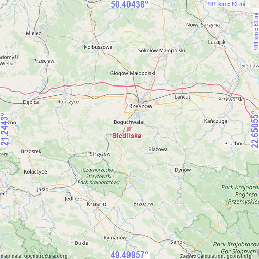
Siedliska GPS coordinates[2]
49° 57' 14.724" North, 21° 56' 50.712" East
| Map corner | latitude | longitude |
|---|---|---|
| Upper-left | 50.40436°, | 21.2443° |
| Center: | 49.95409°, | 21.94742° |
| Lower-right: | 49.49957°, | 22.65055° |
| Map W x H: | 100.6×100.6 km | = 62.5×62.5mi |
| max Lat: | 54.83135° ⇑85.1% North |
| Siedliska: | 49.95409° |
| min Lat: | ⇓14.9% South 49.21328° |
| min Long | Siedliska | max Long |
| 14.20249° | 21.94742° | 24.03723° |
| W 84.1%⇐ | ⇒15.9% E |
Elevation
Elevation of Siedliska is 210 m = 689 ft, and this is 18.6 m = 61 ft above average elevation for this country.
| Max E: |
974 m = 3196 ft | 36.7% |
| Siedliska | 210 m 689 ft | |
| Avg. | 191.4 m = 628 ft | |
Min E: |
-3 m = -10 ft | 63.3% |
See also: Poland elevation on elevation.city.
Geographical zone
Siedliska is located in North temperate zone (between Tropic of Cancer and the Arctic Circle). Distance of this North polar circle is 1846.8 km =1147.5 mi to North.| Distance of | km | miles | from Siedliska |
|---|---|---|---|
| North Pole | 4452.7 | 2766.8 | to North |
| Arctic Circle | 1846.8 | 1147.5 | to North |
| Tropic Cancer | 2948.5 | 1832.1 | to South |
| Equator | 5554.4 | 3451.3 | to South |


Nearby cities:
15 places around Siedliska: (largest is in red/bold)
• Babica
5.9 km =3.7 mi,  248°
248°
• Boguchwała
3.4 km =2.1 mi,  357°
357°
• Czudec
7.7 km =4.8 mi,  262°
262°
• Kielanówka
8.1 km =5 mi,  350°
350°
• Lecka
9.6 km =6 mi,  150°
150°
• Lubenia
3 km =1.9 mi,  209°
209°
• Lutoryż
2.9 km =1.8 mi,  300°
300°
• Niechobrz
6.7 km =4.2 mi,  312°
312°
• Połomia
6.8 km =4.2 mi,  215°
215°
• Przybyszówka
10.5 km =6.5 mi, 351°
• Rzeszów
10.4 km =6.5 mi,  20°
20°
• Straszydle
6.4 km =4 mi,  157°
157°
• Tyczyn
6.3 km =3.9 mi,  80°
80°
• Zarzecze
2.1 km =1.3 mi, 261°
• Zgłobień
9.3 km =5.8 mi, 314°
Sources, notices
• [Note1] Compared only with cities in Poland existing in our database
• [Src1] Map data: © OpenStreetMap contributors (CC-BY-SA)
• [Src2] Other city data from geonames.org with taken over terms of usage.
• [Src3] Geographical zone / Annual Mean Temperature by Robert A. Rohde @ Wikipedia
