Błażowa geodata
Błażowa (Subcarpathian) is a seat of a third-order administrative division; located in Poland in Europe/Warsaw (GMT+2) time zone. With population of 2,129 people, there are 1396 cities with bigger population in this country. Compared to other cities in Poland, 88.2% of cities are located further ↑North; 86% of cities are located further ←West and 74.8% of cities have lower elevation than Błażowa. Note1


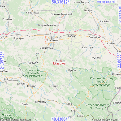
Błażowa GPS coordinates[2]
49° 53' 6.756" North, 22° 6' 1.332" East
| Map corner | latitude | longitude |
|---|---|---|
| Upper-left | 50.33612°, | 21.39725° |
| Center: | 49.88521°, | 22.10037° |
| Lower-right: | 49.43004°, | 22.8035° |
| Map W x H: | 100.7×100.7 km | = 62.6×62.6mi |
| max Lat: | 54.83135° ⇑88.2% North |
| Błażowa: | 49.88521° |
| min Lat: | ⇓11.8% South 49.21328° |
| min Long | Błażowa | max Long |
| 14.20249° | 22.10037° | 24.03723° |
| W 86%⇐ | ⇒14% E |
Elevation
Elevation of Błażowa is 246 m = 807 ft, and this is 54.6 m = 179 ft above average elevation for this country.
| Max E: |
974 m = 3196 ft | 25.2% |
| Błażowa | 246 m 807 ft | |
| Avg. | 191.4 m = 628 ft | |
Min E: |
-3 m = -10 ft | 74.8% |
See also: Poland elevation on elevation.city.
Geographical zone
Błażowa is located in North temperate zone (between Tropic of Cancer and the Arctic Circle). Distance of this North polar circle is 1854.5 km =1152.3 mi to North.| Distance of | km | miles | from Błażowa |
|---|---|---|---|
| North Pole | 4460.3 | 2771.5 | to North |
| Arctic Circle | 1854.5 | 1152.3 | to North |
| Tropic Cancer | 2940.8 | 1827.3 | to South |
| Equator | 5546.7 | 3446.6 | to South |


Nearby cities:
15 places around Błażowa: (largest is in red/bold)
• Białka
4.9 km =3 mi,  251°
251°
• Chmielnik
10.4 km =6.5 mi,  18°
18°
• Dynów
12.3 km =7.6 mi,  129°
129°
• Golcowa
13.7 km =8.5 mi,  203°
203°
• Gwoźnica Górna
9.7 km =6 mi,  229°
229°
• Hyżne
6.8 km =4.2 mi,  58°
58°
• Jawornik Polski
13.5 km =8.4 mi,  87°
87°
• Konieczkowa
13.2 km =8.2 mi, 248°
• Lecka
6.3 km =3.9 mi,  263°
263°
• Lubenia
13.4 km =8.3 mi,  292°
292°
• Nozdrzec
14.3 km =8.9 mi,  150°
150°
• Siedliska
13.4 km =8.3 mi,  304°
304°
• Straszydle
8.7 km =5.4 mi,  281°
281°
• Tyczyn
10 km =6.2 mi,  331°
331°
• Wesoła
9.5 km =5.9 mi,  180°
180°
Sources, notices
• [Note1] Compared only with cities in Poland existing in our database
• [Src1] Map data: © OpenStreetMap contributors (CC-BY-SA)
• [Src2] Other city data from geonames.org with taken over terms of usage.
• [Src3] Geographical zone / Annual Mean Temperature by Robert A. Rohde @ Wikipedia
