Tyczyn geodata
Tyczyn (Subcarpathian) is a seat of a third-order administrative division; located in Poland in Europe/Warsaw (GMT+2) time zone. With population of 3,393 people, there are 942 cities with bigger population in this country. Compared to other cities in Poland, 84.7% of cities are located further ↑North; 85.3% of cities are located further ←West and 69.6% of cities have lower elevation than Tyczyn. Note1


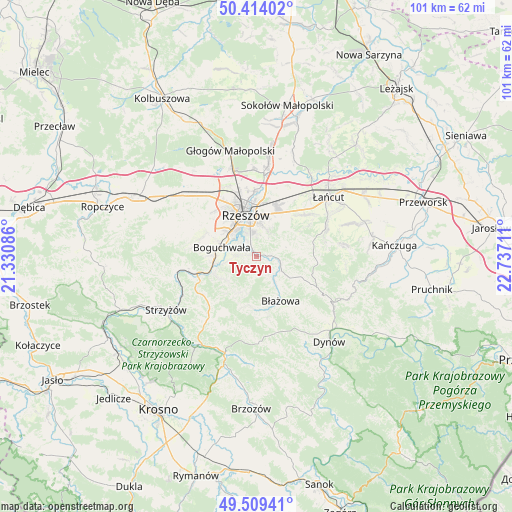
Tyczyn GPS coordinates[2]
49° 57' 49.824" North, 22° 2' 2.328" East
| Map corner | latitude | longitude |
|---|---|---|
| Upper-left | 50.41402°, | 21.33086° |
| Center: | 49.96384°, | 22.03398° |
| Lower-right: | 49.50941°, | 22.73711° |
| Map W x H: | 100.6×100.6 km | = 62.5×62.5mi |
| max Lat: | 54.83135° ⇑84.7% North |
| Tyczyn: | 49.96384° |
| min Lat: | ⇓15.3% South 49.21328° |
| min Long | Tyczyn | max Long |
| 14.20249° | 22.03398° | 24.03723° |
| W 85.3%⇐ | ⇒14.7% E |
Elevation
Elevation of Tyczyn is 228 m = 748 ft, and this is 36.6 m = 120 ft above average elevation for this country.
| Max E: |
974 m = 3196 ft | 30.4% |
| Tyczyn | 228 m 748 ft | |
| Avg. | 191.4 m = 628 ft | |
Min E: |
-3 m = -10 ft | 69.6% |
See also: Poland elevation on elevation.city.
Geographical zone
Tyczyn is located in North temperate zone (between Tropic of Cancer and the Arctic Circle). Distance of this North polar circle is 1845.7 km =1146.9 mi to North.| Distance of | km | miles | from Tyczyn |
|---|---|---|---|
| North Pole | 4451.6 | 2766.1 | to North |
| Arctic Circle | 1845.7 | 1146.9 | to North |
| Tropic Cancer | 2949.5 | 1832.7 | to South |
| Equator | 5555.5 | 3452 | to South |


Nearby cities:
15 places around Tyczyn: (largest is in red/bold)
• Białka
10.3 km =6.4 mi,  179°
179°
• Boguchwała
6.8 km =4.2 mi,  290°
290°
• Błażowa
10 km =6.2 mi,  151°
151°
• Chmielnik
8 km =5 mi,  82°
82°
• Hyżne
11.7 km =7.3 mi,  115°
115°
• Kielanówka
10.2 km =6.3 mi,  312°
312°
• Krasne
10.9 km =6.8 mi,  20°
20°
• Lecka
9.6 km =6 mi,  188°
188°
• Lubenia
8.5 km =5.3 mi,  244°
244°
• Lutoryż
8.7 km =5.4 mi,  272°
272°
• Niechobrz
11.7 km =7.3 mi, 287°
• Rzeszów
9 km =5.6 mi,  343°
343°
• Siedliska
6.3 km =3.9 mi,  260°
260°
• Straszydle
8 km =5 mi,  208°
208°
• Zarzecze
8.4 km =5.2 mi, 260°
Sources, notices
• [Note1] Compared only with cities in Poland existing in our database
• [Src1] Map data: © OpenStreetMap contributors (CC-BY-SA)
• [Src2] Other city data from geonames.org with taken over terms of usage.
• [Src3] Geographical zone / Annual Mean Temperature by Robert A. Rohde @ Wikipedia
