Tarnobrzeg geodata
Tarnobrzeg (Subcarpathian) is a seat of a second-order administrative division; located in Poland in Europe/Warsaw (GMT+2) time zone. With population of 50,459 people, there are 100 cities with bigger population in this country. Compared to other cities in Poland, 65.9% of cities are located further ↑North; 81.1% of cities are located further ←West and 53.7% of cities have higher elevation than Tarnobrzeg. Note1


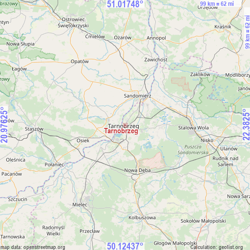
Tarnobrzeg GPS coordinates[2]
50° 34' 22.944" North, 21° 40' 45.732" East
| Map corner | latitude | longitude |
|---|---|---|
| Upper-left | 51.01748°, | 20.97625° |
| Center: | 50.57304°, | 21.67937° |
| Lower-right: | 50.12437°, | 22.3825° |
| Map W x H: | 99.3×99.3 km | = 61.7×61.7mi |
| max Lat: | 54.83135° ⇑65.9% North |
| Tarnobrzeg: | 50.57304° |
| min Lat: | ⇓34.1% South 49.21328° |
| min Long | Tarnobrzeg | max Long |
| 14.20249° | 21.67937° | 24.03723° |
| W 81.1%⇐ | ⇒18.9% E |
Elevation
Elevation of Tarnobrzeg is 162 m = 531 ft, and this is 29.4 m = 96 ft below average elevation for this country.
| Max E: |
974 m = 3196 ft | 53.7% |
| Avg. | 191.4 m = 628 ft | |
| Tarnobrzeg | 162 m = 531 ft | |
Min E: |
-3 m = -10 ft | 46.3% |
See also: Tarnobrzeg elevation on elevation.city.
Geographical zone
Tarnobrzeg is located in North temperate zone (between Tropic of Cancer and the Arctic Circle). Distance of this North polar circle is 1778 km =1104.8 mi to North.| Distance of | km | miles | from Tarnobrzeg |
|---|---|---|---|
| North Pole | 4383.9 | 2724 | to North |
| Arctic Circle | 1778 | 1104.8 | to North |
| Tropic Cancer | 3017.3 | 1874.9 | to South |
| Equator | 5623.2 | 3494.1 | to South |


Nearby cities:
15 places around Tarnobrzeg: (largest is in red/bold)
• Baranów Sandomierski
12.7 km =7.9 mi,  229°
229°
• Gorzyce
15.4 km =9.6 mi,  47°
47°
• Grębów
13.8 km =8.6 mi,  93°
93°
• Koprzywnica
7.1 km =4.4 mi,  288°
288°
• Kępie Żaleszańskie
16.1 km =10 mi,  62°
62°
• Nowa Dęba
16.7 km =10.4 mi,  162°
162°
• Obrazów
13.5 km =8.4 mi,  351°
351°
• Osiek
17.8 km =11.1 mi,  250°
250°
• Samborzec
8.5 km =5.3 mi,  344°
344°
• Sandomierz
13.1 km =8.1 mi,  21°
21°
• Sokolniki
11.5 km =7.1 mi, 51°
• Zaleszany
17.1 km =10.6 mi, 60°
• Złota
9.9 km =6.2 mi,  1°
1°
• Łoniów
10.9 km =6.8 mi,  264°
264°
• Świniary Stare
11.2 km =7 mi, 249°
Sources, notices
• [Note1] Compared only with cities in Poland existing in our database
• [Src1] Map data: © OpenStreetMap contributors (CC-BY-SA)
• [Src2] Other city data from geonames.org with taken over terms of usage.
• [Src3] Geographical zone / Annual Mean Temperature by Robert A. Rohde @ Wikipedia
