Somianka geodata
Somianka (Mazovia) is a populated place; located in Poland in Europe/Warsaw (GMT+2) time zone. With population of 510 people, there are 3513 cities with bigger population in this country. Compared to other cities in Poland, 77.3% of cities are located further ↓South; 76.9% of cities are located further ←West and 81.2% of cities have higher elevation than Somianka. Note1


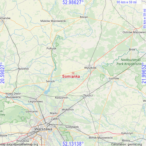
Somianka GPS coordinates[2]
52° 33' 39.276" North, 21° 17' 36.204" East
| Map corner | latitude | longitude |
|---|---|---|
| Upper-left | 52.98627°, | 20.59027° |
| Center: | 52.56091°, | 21.29339° |
| Lower-right: | 52.13138°, | 21.99652° |
| Map W x H: | 95.1×95.1 km | = 59.1×59.1mi |
| max Lat: | 54.83135° ⇑22.7% North |
| Somianka: | 52.56091° |
| min Lat: | ⇓77.3% South 49.21328° |
| min Long | Somianka | max Long |
| 14.20249° | 21.29339° | 24.03723° |
| W 76.9%⇐ | ⇒23.1% E |
Elevation
Elevation of Somianka is 97 m = 318 ft, and this is 94.4 m = 310 ft below average elevation for this country.
| Max E: |
974 m = 3196 ft | 81.2% |
| Avg. | 191.4 m = 628 ft | |
| Somianka | 97 m = 318 ft | |
Min E: |
-3 m = -10 ft | 18.8% |
See also: Poland elevation on elevation.city.
Geographical zone
Somianka is located in North temperate zone (between Tropic of Cancer and the Arctic Circle). Distance of this North polar circle is 1556.9 km =967.4 mi to North.| Distance of | km | miles | from Somianka |
|---|---|---|---|
| North Pole | 4162.8 | 2586.6 | to North |
| Arctic Circle | 1556.9 | 967.4 | to North |
| Tropic Cancer | 3238.3 | 2012.2 | to South |
| Equator | 5844.2 | 3631.4 | to South |


Nearby cities:
15 places around Somianka: (largest is in red/bold)
• Dąbrówka
8.6 km =5.3 mi,  177°
177°
• Jasienica
18.2 km =11.3 mi,  153°
153°
• Klembów
17.4 km =10.8 mi,  171°
171°
• Obryte
17.5 km =10.9 mi,  350°
350°
• Ostrówek
19.7 km =12.2 mi, 165°
• Pokrzywnica
19.7 km =12.2 mi,  289°
289°
• Psary
18.4 km =11.4 mi,  337°
337°
• Radzymin
17.7 km =11 mi,  204°
204°
• Rybno
7.8 km =4.8 mi,  83°
83°
• Rząśnik
17.7 km =11 mi,  16°
16°
• Serock
16.2 km =10.1 mi,  249°
249°
• Tłuszcz
17.4 km =10.8 mi, 146°
• Wyszków
11.7 km =7.3 mi,  72°
72°
• Zabrodzie
10.2 km =6.3 mi,  123°
123°
• Zatory
8.6 km =5.3 mi,  299°
299°
Sources, notices
• [Note1] Compared only with cities in Poland existing in our database
• [Src1] Map data: © OpenStreetMap contributors (CC-BY-SA)
• [Src2] Other city data from geonames.org with taken over terms of usage.
• [Src3] Geographical zone / Annual Mean Temperature by Robert A. Rohde @ Wikipedia
