Zatory geodata
Zatory (Mazovia) is a seat of a third-order administrative division; located in Poland in Europe/Warsaw (GMT+2) time zone. With population of 970 people, there are 2550 cities with bigger population in this country. Compared to other cities in Poland, 77.9% of cities are located further ↓South; 75.5% of cities are located further ←West and 81.8% of cities have higher elevation than Zatory. Note1


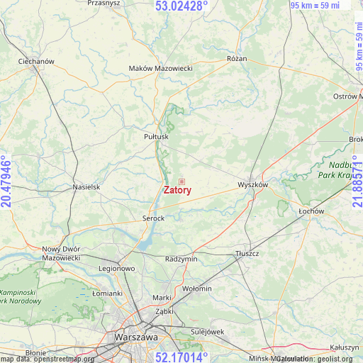
Zatory GPS coordinates[2]
52° 35' 57.444" North, 21° 10' 57.288" East
| Map corner | latitude | longitude |
|---|---|---|
| Upper-left | 53.02428°, | 20.47946° |
| Center: | 52.59929°, | 21.18258° |
| Lower-right: | 52.17014°, | 21.88571° |
| Map W x H: | 95×95 km | = 59×59mi |
| max Lat: | 54.83135° ⇑22.1% North |
| Zatory: | 52.59929° |
| min Lat: | ⇓77.9% South 49.21328° |
| min Long | Zatory | max Long |
| 14.20249° | 21.18258° | 24.03723° |
| W 75.5%⇐ | ⇒24.5% E |
Elevation
Elevation of Zatory is 96 m = 315 ft, and this is 95.4 m = 313 ft below average elevation for this country.
| Max E: |
974 m = 3196 ft | 81.8% |
| Avg. | 191.4 m = 628 ft | |
| Zatory | 96 m = 315 ft | |
Min E: |
-3 m = -10 ft | 18.2% |
See also: Poland elevation on elevation.city.
Geographical zone
Zatory is located in North temperate zone (between Tropic of Cancer and the Arctic Circle). Distance of this North polar circle is 1552.7 km =964.8 mi to North.| Distance of | km | miles | from Zatory |
|---|---|---|---|
| North Pole | 4158.6 | 2584 | to North |
| Arctic Circle | 1552.7 | 964.8 | to North |
| Tropic Cancer | 3242.6 | 2014.9 | to South |
| Equator | 5848.5 | 3634.1 | to South |


Nearby cities:
15 places around Zatory: (largest is in red/bold)
• Białobrzegi
19.6 km =12.2 mi,  206°
206°
• Dąbrówka
15 km =9.3 mi,  148°
148°
• Nieporęt
21.3 km =13.2 mi, 208°
• Obryte
13.8 km =8.6 mi,  19°
19°
• Pokrzywnica
11.3 km =7 mi,  282°
282°
• Psary
12.8 km =8 mi,  2°
2°
• Pułtusk
13.3 km =8.3 mi,  329°
329°
• Radzymin
20.4 km =12.7 mi,  179°
179°
• Rybno
15.6 km =9.7 mi,  102°
102°
• Rząśnik
17.8 km =11.1 mi,  44°
44°
• Serock
12.5 km =7.8 mi,  217°
217°
• Somianka
8.6 km =5.3 mi,  119°
119°
• Winnica
17 km =10.6 mi,  286°
286°
• Wyszków
18.6 km =11.6 mi,  92°
92°
• Zabrodzie
18.8 km =11.7 mi, 121°
Sources, notices
• [Note1] Compared only with cities in Poland existing in our database
• [Src1] Map data: © OpenStreetMap contributors (CC-BY-SA)
• [Src2] Other city data from geonames.org with taken over terms of usage.
• [Src3] Geographical zone / Annual Mean Temperature by Robert A. Rohde @ Wikipedia
