Psary geodata
Psary (Mazovia) is a populated place; located in Poland in Europe/Warsaw (GMT+2) time zone. With population of 530 people, there are 3452 cities with bigger population in this country. Compared to other cities in Poland, 79.5% of cities are located further ↓South; 75.7% of cities are located further ←West and 81.8% of cities have higher elevation than Psary. Note1


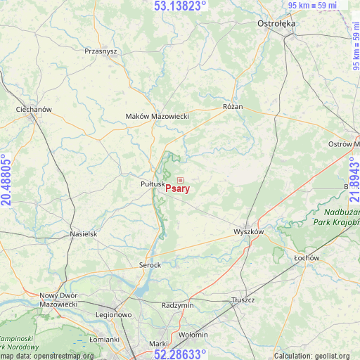
Psary GPS coordinates[2]
52° 42' 51.696" North, 21° 11' 28.212" East
| Map corner | latitude | longitude |
|---|---|---|
| Upper-left | 53.13823°, | 20.48805° |
| Center: | 52.71436°, | 21.19117° |
| Lower-right: | 52.28633°, | 21.8943° |
| Map W x H: | 94.7×94.7 km | = 58.8×58.8mi |
| max Lat: | 54.83135° ⇑20.5% North |
| Psary: | 52.71436° |
| min Lat: | ⇓79.5% South 49.21328° |
| min Long | Psary | max Long |
| 14.20249° | 21.19117° | 24.03723° |
| W 75.7%⇐ | ⇒24.3% E |
Elevation
Elevation of Psary is 96 m = 315 ft, and this is 95.4 m = 313 ft below average elevation for this country.
| Max E: |
974 m = 3196 ft | 81.8% |
| Avg. | 191.4 m = 628 ft | |
| Psary | 96 m = 315 ft | |
Min E: |
-3 m = -10 ft | 18.2% |
See also: Poland elevation on elevation.city.
Geographical zone
Psary is located in North temperate zone (between Tropic of Cancer and the Arctic Circle). Distance of this North polar circle is 1539.9 km =956.8 mi to North.| Distance of | km | miles | from Psary |
|---|---|---|---|
| North Pole | 4145.8 | 2576.1 | to North |
| Arctic Circle | 1539.9 | 956.8 | to North |
| Tropic Cancer | 3255.4 | 2022.8 | to South |
| Equator | 5861.3 | 3642 | to South |


Nearby cities:
15 places around Psary: (largest is in red/bold)
• Czerwonka
19.9 km =12.4 mi,  4°
4°
• Gzy
16.9 km =10.5 mi,  279°
279°
• Karniewo
19.3 km =12 mi,  315°
315°
• Maków Mazowiecki
17.8 km =11.1 mi,  339°
339°
• Obryte
3.9 km =2.4 mi,  86°
86°
• Pokrzywnica
15.6 km =9.7 mi,  228°
228°
• Pułtusk
7.4 km =4.6 mi,  259°
259°
• Rybno
21.8 km =13.5 mi,  137°
137°
• Rzewnie
16.6 km =10.3 mi,  36°
36°
• Rząśnik
11.9 km =7.4 mi, 90°
• Somianka
18.4 km =11.4 mi,  157°
157°
• Szelków
13.5 km =8.4 mi,  7°
7°
• Winnica
18.6 km =11.6 mi,  244°
244°
• Wyszków
22.5 km =14 mi,  126°
126°
• Zatory
12.8 km =8 mi,  182°
182°
Sources, notices
• [Note1] Compared only with cities in Poland existing in our database
• [Src1] Map data: © OpenStreetMap contributors (CC-BY-SA)
• [Src2] Other city data from geonames.org with taken over terms of usage.
• [Src3] Geographical zone / Annual Mean Temperature by Robert A. Rohde @ Wikipedia
