Obryte geodata
Obryte (Mazovia) is a seat of a third-order administrative division; located in Poland in Europe/Warsaw (GMT+2) time zone. With population of 930 people, there are 2620 cities with bigger population in this country. Compared to other cities in Poland, 79.5% of cities are located further ↓South; 76.3% of cities are located further ←West and 75.8% of cities have higher elevation than Obryte. Note1


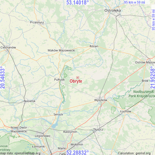
Obryte GPS coordinates[2]
52° 42' 58.788" North, 21° 14' 58.02" East
| Map corner | latitude | longitude |
|---|---|---|
| Upper-left | 53.14018°, | 20.54633° |
| Center: | 52.71633°, | 21.24945° |
| Lower-right: | 52.28832°, | 21.95258° |
| Map W x H: | 94.7×94.7 km | = 58.8×58.8mi |
| max Lat: | 54.83135° ⇑20.5% North |
| Obryte: | 52.71633° |
| min Lat: | ⇓79.5% South 49.21328° |
| min Long | Obryte | max Long |
| 14.20249° | 21.24945° | 24.03723° |
| W 76.3%⇐ | ⇒23.7% E |
Elevation
Elevation of Obryte is 109 m = 358 ft, and this is 82.4 m = 270 ft below average elevation for this country.
| Max E: |
974 m = 3196 ft | 75.8% |
| Avg. | 191.4 m = 628 ft | |
| Obryte | 109 m = 358 ft | |
Min E: |
-3 m = -10 ft | 24.2% |
See also: Poland elevation on elevation.city.
Geographical zone
Obryte is located in North temperate zone (between Tropic of Cancer and the Arctic Circle). Distance of this North polar circle is 1539.7 km =956.7 mi to North.| Distance of | km | miles | from Obryte |
|---|---|---|---|
| North Pole | 4145.6 | 2576 | to North |
| Arctic Circle | 1539.7 | 956.7 | to North |
| Tropic Cancer | 3255.6 | 2022.9 | to South |
| Equator | 5861.5 | 3642.2 | to South |


Nearby cities:
15 places around Obryte: (largest is in red/bold)
• Czerwonka
19.7 km =12.2 mi,  353°
353°
• Gzy
20.8 km =12.9 mi,  277°
277°
• Karniewo
22.1 km =13.7 mi,  307°
307°
• Maków Mazowiecki
19.3 km =12 mi,  328°
328°
• Pokrzywnica
18.8 km =11.7 mi,  235°
235°
• Psary
3.9 km =2.4 mi,  266°
266°
• Pułtusk
11.3 km =7 mi,  262°
262°
• Rybno
19.6 km =12.2 mi,  146°
146°
• Rzewnie
14.5 km =9 mi,  23°
23°
• Rząśnik
8 km =5 mi,  92°
92°
• Różan
21.3 km =13.2 mi,  26°
26°
• Somianka
17.5 km =10.9 mi,  170°
170°
• Szelków
13.4 km =8.3 mi, 350°
• Wyszków
19.7 km =12.2 mi,  134°
134°
• Zatory
13.8 km =8.6 mi,  199°
199°
Sources, notices
• [Note1] Compared only with cities in Poland existing in our database
• [Src1] Map data: © OpenStreetMap contributors (CC-BY-SA)
• [Src2] Other city data from geonames.org with taken over terms of usage.
• [Src3] Geographical zone / Annual Mean Temperature by Robert A. Rohde @ Wikipedia
