Rząśnik geodata
Rząśnik (Mazovia) is a populated place; located in Poland in Europe/Warsaw (GMT+2) time zone. With population of 1,600 people, there are 1751 cities with bigger population in this country. Compared to other cities in Poland, 79.5% of cities are located further ↓South; 77.7% of cities are located further ←West and 77.6% of cities have higher elevation than Rząśnik. Note1


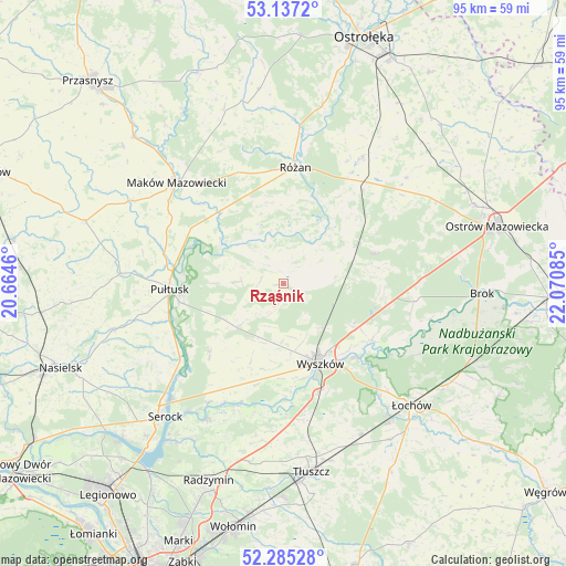
Rząśnik GPS coordinates[2]
52° 42' 47.952" North, 21° 22' 3.792" East
| Map corner | latitude | longitude |
|---|---|---|
| Upper-left | 53.1372°, | 20.6646° |
| Center: | 52.71332°, | 21.36772° |
| Lower-right: | 52.28528°, | 22.07085° |
| Map W x H: | 94.7×94.7 km | = 58.8×58.8mi |
| max Lat: | 54.83135° ⇑20.5% North |
| Rząśnik: | 52.71332° |
| min Lat: | ⇓79.5% South 49.21328° |
| min Long | Rząśnik | max Long |
| 14.20249° | 21.36772° | 24.03723° |
| W 77.7%⇐ | ⇒22.3% E |
Elevation
Elevation of Rząśnik is 104 m = 341 ft, and this is 87.4 m = 287 ft below average elevation for this country.
| Max E: |
974 m = 3196 ft | 77.6% |
| Avg. | 191.4 m = 628 ft | |
| Rząśnik | 104 m = 341 ft | |
Min E: |
-3 m = -10 ft | 22.4% |
See also: Poland elevation on elevation.city.
Geographical zone
Rząśnik is located in North temperate zone (between Tropic of Cancer and the Arctic Circle). Distance of this North polar circle is 1540 km =956.9 mi to North.| Distance of | km | miles | from Rząśnik |
|---|---|---|---|
| North Pole | 4145.9 | 2576.1 | to North |
| Arctic Circle | 1540 | 956.9 | to North |
| Tropic Cancer | 3255.3 | 2022.7 | to South |
| Equator | 5861.2 | 3642 | to South |


Nearby cities:
15 places around Rząśnik: (largest is in red/bold)
• Brańszczyk
17.5 km =10.9 mi,  122°
122°
• Czerwonka
22.4 km =13.9 mi,  332°
332°
• Długosiodło
16 km =9.9 mi,  71°
71°
• Goworowo
24.4 km =15.2 mi,  31°
31°
• Obryte
8 km =5 mi,  272°
272°
• Psary
11.9 km =7.4 mi, 270°
• Pułtusk
19.2 km =11.9 mi, 266°
• Rybno
16.3 km =10.1 mi,  170°
170°
• Rzewnie
13.7 km =8.5 mi,  351°
351°
• Różan
19.4 km =12.1 mi,  4°
4°
• Somianka
17.7 km =11 mi,  196°
196°
• Szelków
16.9 km =10.5 mi,  323°
323°
• Wyszków
14.7 km =9.1 mi,  155°
155°
• Zabrodzie
22.8 km =14.2 mi, 171°
• Zatory
17.8 km =11.1 mi,  224°
224°
Sources, notices
• [Note1] Compared only with cities in Poland existing in our database
• [Src1] Map data: © OpenStreetMap contributors (CC-BY-SA)
• [Src2] Other city data from geonames.org with taken over terms of usage.
• [Src3] Geographical zone / Annual Mean Temperature by Robert A. Rohde @ Wikipedia
