Szydłowiec geodata
Szydłowiec (Mazovia) is a seat of a second-order administrative division; located in Poland in Europe/Warsaw (GMT+2) time zone. With population of 12,128 people, there are 394 cities with bigger population in this country. Compared to other cities in Poland, 51.6% of cities are located further ↓South; 70.2% of cities are located further ←West and 68.1% of cities have lower elevation than Szydłowiec. Note1


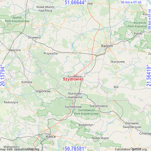
Szydłowiec GPS coordinates[2]
51° 13' 41.628" North, 20° 51' 39.816" East
| Map corner | latitude | longitude |
|---|---|---|
| Upper-left | 51.66644°, | 20.15794° |
| Center: | 51.22823°, | 20.86106° |
| Lower-right: | 50.78581°, | 21.56419° |
| Map W x H: | 97.9×97.9 km | = 60.8×60.8mi |
| max Lat: | 54.83135° ⇑48.4% North |
| Szydłowiec: | 51.22823° |
| min Lat: | ⇓51.6% South 49.21328° |
| min Long | Szydłowiec | max Long |
| 14.20249° | 20.86106° | 24.03723° |
| W 70.2%⇐ | ⇒29.8% E |
Elevation
Elevation of Szydłowiec is 223 m = 732 ft, and this is 31.6 m = 104 ft above average elevation for this country.
| Max E: |
974 m = 3196 ft | 31.9% |
| Szydłowiec | 223 m 732 ft | |
| Avg. | 191.4 m = 628 ft | |
Min E: |
-3 m = -10 ft | 68.1% |
See also: Poland elevation on elevation.city.
Geographical zone
Szydłowiec is located in North temperate zone (between Tropic of Cancer and the Arctic Circle). Distance of this North polar circle is 1705.1 km =1059.5 mi to North.| Distance of | km | miles | from Szydłowiec |
|---|---|---|---|
| North Pole | 4311 | 2678.7 | to North |
| Arctic Circle | 1705.1 | 1059.5 | to North |
| Tropic Cancer | 3090.1 | 1920.1 | to South |
| Equator | 5696 | 3539.3 | to South |


Nearby cities:
15 places around Szydłowiec: (largest is in red/bold)
• Bliżyn
15.2 km =9.4 mi,  207°
207°
• Borkowice
16 km =9.9 mi,  309°
309°
• Chlewiska
6.7 km =4.2 mi,  285°
285°
• Grzybowa Góra
12.7 km =7.9 mi,  146°
146°
• Jastrząb
6.4 km =4 mi,  70°
70°
• Mirów
12.5 km =7.8 mi,  106°
106°
• Mirów Stary
13.5 km =8.4 mi, 110°
• Orońsko
13.1 km =8.1 mi,  43°
43°
• Pawłów
4.3 km =2.7 mi, 311°
• Rogów
10.8 km =6.7 mi, 107°
• Rzeczków
14.5 km =9 mi, 72°
• Skarżysko Kościelne
10.6 km =6.6 mi,  160°
160°
• Skarżysko-Kamienna
12.8 km =8 mi,  176°
176°
• Wieniawa
15.5 km =9.6 mi,  342°
342°
• Wierzbica
15.6 km =9.7 mi,  81°
81°
Sources, notices
• [Note1] Compared only with cities in Poland existing in our database
• [Src1] Map data: © OpenStreetMap contributors (CC-BY-SA)
• [Src2] Other city data from geonames.org with taken over terms of usage.
• [Src3] Geographical zone / Annual Mean Temperature by Robert A. Rohde @ Wikipedia
