Jastrząb geodata
Jastrząb (Mazovia) is a seat of a third-order administrative division; located in Poland in Europe/Warsaw (GMT+2) time zone. With population of 891 people, there are 2693 cities with bigger population in this country. Compared to other cities in Poland, 52% of cities are located further ↓South; 71.6% of cities are located further ←West and 57.5% of cities have lower elevation than Jastrząb. Note1


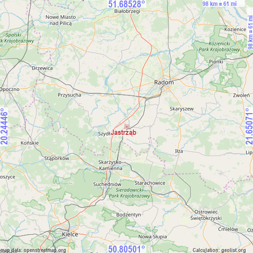
Jastrząb GPS coordinates[2]
51° 14' 50.1" North, 20° 56' 51.288" East
| Map corner | latitude | longitude |
|---|---|---|
| Upper-left | 51.68528°, | 20.24446° |
| Center: | 51.24725°, | 20.94758° |
| Lower-right: | 50.80501°, | 21.65071° |
| Map W x H: | 97.9×97.9 km | = 60.8×60.8mi |
| max Lat: | 54.83135° ⇑48% North |
| Jastrząb: | 51.24725° |
| min Lat: | ⇓52% South 49.21328° |
| min Long | Jastrząb | max Long |
| 14.20249° | 20.94758° | 24.03723° |
| W 71.6%⇐ | ⇒28.4% E |
Elevation
Elevation of Jastrząb is 192 m = 630 ft, and this is 0.59999999999999 m = 2 ft above average elevation for this country.
| Max E: |
974 m = 3196 ft | 42.5% |
| Jastrząb | 192 m 630 ft | |
| Avg. | 191.4 m = 628 ft | |
Min E: |
-3 m = -10 ft | 57.5% |
See also: Poland elevation on elevation.city.
Geographical zone
Jastrząb is located in North temperate zone (between Tropic of Cancer and the Arctic Circle). Distance of this North polar circle is 1703 km =1058.2 mi to North.| Distance of | km | miles | from Jastrząb |
|---|---|---|---|
| North Pole | 4308.9 | 2677.4 | to North |
| Arctic Circle | 1703 | 1058.2 | to North |
| Tropic Cancer | 3092.2 | 1921.4 | to South |
| Equator | 5698.2 | 3540.7 | to South |


Nearby cities:
15 places around Jastrząb: (largest is in red/bold)
• Chlewiska
12.5 km =7.8 mi,  268°
268°
• Grzybowa Góra
12.7 km =7.9 mi,  175°
175°
• Kowala
12.1 km =7.5 mi,  44°
44°
• Ludwinów
15.2 km =9.4 mi, 42°
• Mirzec
14.7 km =9.1 mi,  148°
148°
• Mirów
8.1 km =5 mi,  133°
133°
• Mirów Stary
9.5 km =5.9 mi,  135°
135°
• Orońsko
7.9 km =4.9 mi,  22°
22°
• Pawłów
9.3 km =5.8 mi, 274°
• Rogów
6.9 km =4.3 mi, 141°
• Rzeczków
8.1 km =5 mi,  74°
74°
• Skarżysko Kościelne
12.4 km =7.7 mi,  191°
191°
• Szydłowiec
6.4 km =4 mi,  250°
250°
• Wierzbica
9.4 km =5.8 mi,  88°
88°
• Wolanów
14.9 km =9.3 mi,  7°
7°
Sources, notices
• [Note1] Compared only with cities in Poland existing in our database
• [Src1] Map data: © OpenStreetMap contributors (CC-BY-SA)
• [Src2] Other city data from geonames.org with taken over terms of usage.
• [Src3] Geographical zone / Annual Mean Temperature by Robert A. Rohde @ Wikipedia
