Pawłów geodata
Pawłów (Mazovia) is a populated place; located in Poland in Europe/Warsaw (GMT+2) time zone. With population of 780 people, there are 2898 cities with bigger population in this country. Compared to other cities in Poland, 52.2% of cities are located further ↓South; 69.4% of cities are located further ←West and 58.9% of cities have lower elevation than Pawłów. Note1


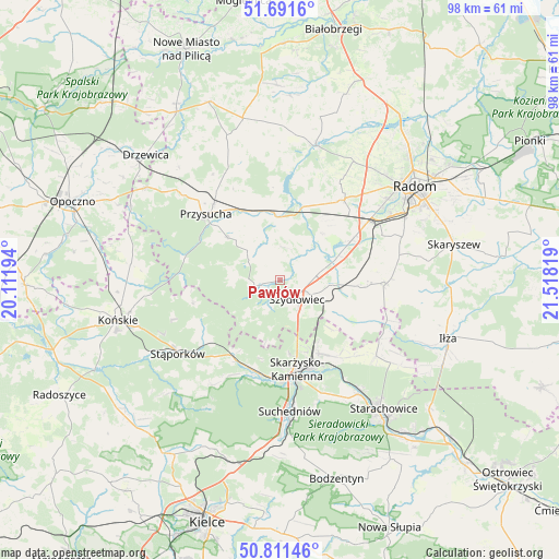
Pawłów GPS coordinates[2]
51° 15' 13.104" North, 20° 48' 54.216" East
| Map corner | latitude | longitude |
|---|---|---|
| Upper-left | 51.6916°, | 20.11194° |
| Center: | 51.25364°, | 20.81506° |
| Lower-right: | 50.81146°, | 21.51819° |
| Map W x H: | 97.9×97.9 km | = 60.8×60.8mi |
| max Lat: | 54.83135° ⇑47.8% North |
| Pawłów: | 51.25364° |
| min Lat: | ⇓52.2% South 49.21328° |
| min Long | Pawłów | max Long |
| 14.20249° | 20.81506° | 24.03723° |
| W 69.4%⇐ | ⇒30.6% E |
Elevation
Elevation of Pawłów is 197 m = 646 ft, and this is 5.6 m = 18 ft above average elevation for this country.
| Max E: |
974 m = 3196 ft | 41.1% |
| Pawłów | 197 m 646 ft | |
| Avg. | 191.4 m = 628 ft | |
Min E: |
-3 m = -10 ft | 58.9% |
See also: Poland elevation on elevation.city.
Geographical zone
Pawłów is located in North temperate zone (between Tropic of Cancer and the Arctic Circle). Distance of this North polar circle is 1702.3 km =1057.8 mi to North.| Distance of | km | miles | from Pawłów |
|---|---|---|---|
| North Pole | 4308.2 | 2677 | to North |
| Arctic Circle | 1702.3 | 1057.8 | to North |
| Tropic Cancer | 3093 | 1921.9 | to South |
| Equator | 5698.9 | 3541.1 | to South |


Nearby cities:
15 places around Pawłów: (largest is in red/bold)
• Bliżyn
16.7 km =10.4 mi,  193°
193°
• Borkowice
11.8 km =7.3 mi,  308°
308°
• Chlewiska
3.4 km =2.1 mi,  251°
251°
• Grzybowa Góra
16.8 km =10.4 mi,  142°
142°
• Jastrząb
9.3 km =5.8 mi,  94°
94°
• Mirów
16.4 km =10.2 mi,  112°
112°
• Orońsko
13.9 km =8.6 mi,  61°
61°
• Przysucha
17.4 km =10.8 mi, 312°
• Rogów
14.8 km =9.2 mi, 114°
• Rzeczków
17.1 km =10.6 mi, 85°
• Skarżysko Kościelne
14.5 km =9 mi,  152°
152°
• Skarżysko-Kamienna
16.1 km =10 mi,  165°
165°
• Szydłowiec
4.3 km =2.7 mi,  131°
131°
• Wielka Wieś
17.2 km =10.7 mi, 245°
• Wieniawa
12.1 km =7.5 mi,  353°
353°
Sources, notices
• [Note1] Compared only with cities in Poland existing in our database
• [Src1] Map data: © OpenStreetMap contributors (CC-BY-SA)
• [Src2] Other city data from geonames.org with taken over terms of usage.
• [Src3] Geographical zone / Annual Mean Temperature by Robert A. Rohde @ Wikipedia
