Rogów geodata
Rogów (Mazovia) is a populated place; located in Poland in Europe/Warsaw (GMT+2) time zone. With population of 784 people, there are 2891 cities with bigger population in this country. Compared to other cities in Poland, 50.9% of cities are located further ↓South; 72.8% of cities are located further ←West and 61% of cities have lower elevation than Rogów. Note1


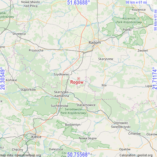
Rogów GPS coordinates[2]
51° 11' 54.204" North, 21° 0' 30.996" East
| Map corner | latitude | longitude |
|---|---|---|
| Upper-left | 51.63688°, | 20.30549° |
| Center: | 51.19839°, | 21.00861° |
| Lower-right: | 50.75568°, | 21.71174° |
| Map W x H: | 98×98 km | = 60.9×60.9mi |
| max Lat: | 54.83135° ⇑49.1% North |
| Rogów: | 51.19839° |
| min Lat: | ⇓50.9% South 49.21328° |
| min Long | Rogów | max Long |
| 14.20249° | 21.00861° | 24.03723° |
| W 72.8%⇐ | ⇒27.2% E |
Elevation
Elevation of Rogów is 203 m = 666 ft, and this is 11.6 m = 38 ft above average elevation for this country.
| Max E: |
974 m = 3196 ft | 39% |
| Rogów | 203 m 666 ft | |
| Avg. | 191.4 m = 628 ft | |
Min E: |
-3 m = -10 ft | 61% |
See also: Poland elevation on elevation.city.
Geographical zone
Rogów is located in North temperate zone (between Tropic of Cancer and the Arctic Circle). Distance of this North polar circle is 1708.4 km =1061.6 mi to North.| Distance of | km | miles | from Rogów |
|---|---|---|---|
| North Pole | 4314.3 | 2680.8 | to North |
| Arctic Circle | 1708.4 | 1061.6 | to North |
| Tropic Cancer | 3086.8 | 1918 | to South |
| Equator | 5692.7 | 3537.3 | to South |


Nearby cities:
15 places around Rogów: (largest is in red/bold)
• Grzybowa Góra
7.9 km =4.9 mi,  204°
204°
• Jastrząb
6.9 km =4.3 mi,  321°
321°
• Kowala
14.7 km =9.1 mi,  16°
16°
• Mirzec
7.9 km =4.9 mi,  154°
154°
• Mirów
1.7 km =1.1 mi,  94°
94°
• Mirów Stary
2.8 km =1.7 mi,  119°
119°
• Orońsko
12.8 km =8 mi,  354°
354°
• Pakosław
11.7 km =7.3 mi, 93°
• Rzeczków
8.4 km =5.2 mi,  25°
25°
• Skarżysko Kościelne
9.5 km =5.9 mi,  225°
225°
• Skarżysko-Kamienna
13.5 km =8.4 mi, 225°
• Szydłowiec
10.8 km =6.7 mi,  287°
287°
• Wielka Wieś
14.5 km =9 mi,  191°
191°
• Wierzbica
7.7 km =4.8 mi,  42°
42°
• Wąchock
13.8 km =8.6 mi,  178°
178°
Sources, notices
• [Note1] Compared only with cities in Poland existing in our database
• [Src1] Map data: © OpenStreetMap contributors (CC-BY-SA)
• [Src2] Other city data from geonames.org with taken over terms of usage.
• [Src3] Geographical zone / Annual Mean Temperature by Robert A. Rohde @ Wikipedia
