Repki geodata
Repki (Mazovia) is a seat of a third-order administrative division; located in Poland in Europe/Warsaw (GMT+2) time zone. With population of 829 people, there are 2806 cities with bigger population in this country. Compared to other cities in Poland, 74.5% of cities are located further ↓South; 90% of cities are located further ←West and 50.8% of cities have higher elevation than Repki. Note1


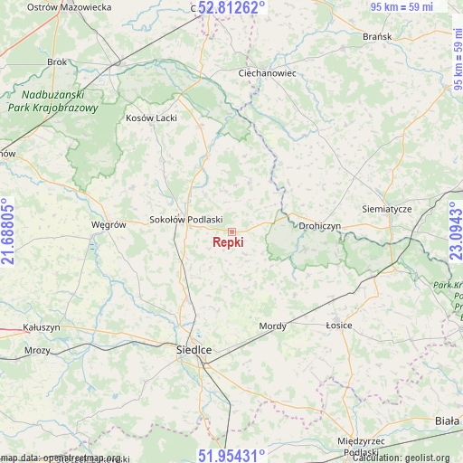
Repki GPS coordinates[2]
52° 23' 7.98" North, 22° 23' 28.212" East
| Map corner | latitude | longitude |
|---|---|---|
| Upper-left | 52.81262°, | 21.68805° |
| Center: | 52.38555°, | 22.39117° |
| Lower-right: | 51.95431°, | 23.0943° |
| Map W x H: | 95.4×95.4 km | = 59.3×59.3mi |
| max Lat: | 54.83135° ⇑25.5% North |
| Repki: | 52.38555° |
| min Lat: | ⇓74.5% South 49.21328° |
| min Long | Repki | max Long |
| 14.20249° | 22.39117° | 24.03723° |
| W 90%⇐ | ⇒10% E |
Elevation
Elevation of Repki is 170 m = 558 ft, and this is 21.4 m = 70 ft below average elevation for this country.
| Max E: |
974 m = 3196 ft | 50.8% |
| Avg. | 191.4 m = 628 ft | |
| Repki | 170 m = 558 ft | |
Min E: |
-3 m = -10 ft | 49.2% |
See also: Poland elevation on elevation.city.
Geographical zone
Repki is located in North temperate zone (between Tropic of Cancer and the Arctic Circle). Distance of this North polar circle is 1576.4 km =979.5 mi to North.| Distance of | km | miles | from Repki |
|---|---|---|---|
| North Pole | 4182.3 | 2598.8 | to North |
| Arctic Circle | 1576.4 | 979.5 | to North |
| Tropic Cancer | 3218.8 | 2000.1 | to South |
| Equator | 5824.7 | 3619.3 | to South |


Nearby cities:
15 places around Repki: (largest is in red/bold)
• Bielany
10.8 km =6.7 mi,  243°
243°
• Drohiczyn
18.2 km =11.3 mi,  84°
84°
• Jabłonna Lacka
10.7 km =6.6 mi,  18°
18°
• Korczew
15.5 km =9.6 mi,  103°
103°
• Miedzna
22.4 km =13.9 mi,  294°
294°
• Mokobody
23.2 km =14.4 mi,  234°
234°
• Mordy
21.2 km =13.2 mi,  156°
156°
• Paprotnia
10.8 km =6.7 mi,  151°
151°
• Perlejewo
23.3 km =14.5 mi,  30°
30°
• Przesmyki
18.5 km =11.5 mi,  134°
134°
• Sabnie
14 km =8.7 mi,  336°
336°
• Siedlce
25.2 km =15.7 mi,  195°
195°
• Sokołów Podlaski
9.7 km =6 mi,  284°
284°
• Sterdyń
22.6 km =14 mi, 343°
• Suchożebry
16.9 km =10.5 mi,  213°
213°
Sources, notices
• [Note1] Compared only with cities in Poland existing in our database
• [Src1] Map data: © OpenStreetMap contributors (CC-BY-SA)
• [Src2] Other city data from geonames.org with taken over terms of usage.
• [Src3] Geographical zone / Annual Mean Temperature by Robert A. Rohde @ Wikipedia
