Sokołów Podlaski geodata
Sokołów Podlaski (Mazovia) is a seat of a second-order administrative division; located in Poland in Europe/Warsaw (GMT+2) time zone. With population of 18,241 people, there are 271 cities with bigger population in this country. Compared to other cities in Poland, 74.8% of cities are located further ↓South; 88.1% of cities are located further ←West and 50.2% of cities have lower elevation than Sokołów Podlaski. Note1


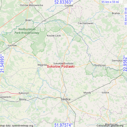
Sokołów Podlaski GPS coordinates[2]
52° 24' 24.372" North, 22° 15' 11.052" East
| Map corner | latitude | longitude |
|---|---|---|
| Upper-left | 52.83363°, | 21.54995° |
| Center: | 52.40677°, | 22.25307° |
| Lower-right: | 51.97574°, | 22.9562° |
| Map W x H: | 95.4×95.4 km | = 59.3×59.3mi |
| max Lat: | 54.83135° ⇑25.2% North |
| Sokołów Podlaski: | 52.40677° |
| min Lat: | ⇓74.8% South 49.21328° |
| min Long | Sokołów Podla | max Long |
| 14.20249° | 22.25307° | 24.03723° |
| W 88.1%⇐ | ⇒11.9% E |
Elevation
Elevation of Sokołów Podlaski is 172 m = 564 ft, and this is 19.4 m = 64 ft below average elevation for this country.
| Max E: |
974 m = 3196 ft | 49.8% |
| Avg. | 191.4 m = 628 ft | |
| Sokołów Podlaski | 172 m = 564 ft | |
Min E: |
-3 m = -10 ft | 50.2% |
See also: Poland elevation on elevation.city.
Geographical zone
Sokołów Podlaski is located in North temperate zone (between Tropic of Cancer and the Arctic Circle). Distance of this North polar circle is 1574.1 km =978.1 mi to North.| Distance of | km | miles | from Sokołów Podlaski |
|---|---|---|---|
| North Pole | 4180 | 2597.3 | to North |
| Arctic Circle | 1574.1 | 978.1 | to North |
| Tropic Cancer | 3221.2 | 2001.6 | to South |
| Equator | 5827.1 | 3620.8 | to South |


Nearby cities:
15 places around Sokołów Podlaski: (largest is in red/bold)
• Bielany
7.2 km =4.5 mi,  182°
182°
• Ceranów
25 km =15.5 mi,  356°
356°
• Jabłonna Lacka
15 km =9.3 mi,  58°
58°
• Korczew
25.2 km =15.7 mi,  103°
103°
• Kosów Lacki
22.2 km =13.8 mi,  341°
341°
• Liw
19.7 km =12.2 mi,  259°
259°
• Miedzna
13 km =8.1 mi,  301°
301°
• Mokobody
18.4 km =11.4 mi,  211°
211°
• Paprotnia
18.7 km =11.6 mi,  128°
128°
• Repki
9.7 km =6 mi, 104°
• Sabnie
11.1 km =6.9 mi,  19°
19°
• Siedlce
26.7 km =16.6 mi,  174°
174°
• Sterdyń
19.5 km =12.1 mi,  8°
8°
• Suchożebry
16.4 km =10.2 mi, 180°
• Węgrów
16.1 km =10 mi,  267°
267°
Sources, notices
• [Note1] Compared only with cities in Poland existing in our database
• [Src1] Map data: © OpenStreetMap contributors (CC-BY-SA)
• [Src2] Other city data from geonames.org with taken over terms of usage.
• [Src3] Geographical zone / Annual Mean Temperature by Robert A. Rohde @ Wikipedia
