Bielany geodata
Bielany (Mazovia) is a seat of a third-order administrative division; located in Poland in Europe/Warsaw (GMT+2) time zone. With population of 168 people, there are 3646 cities with bigger population in this country. Compared to other cities in Poland, 73.5% of cities are located further ↓South; 88% of cities are located further ←West and 55.3% of cities have higher elevation than Bielany. Note1


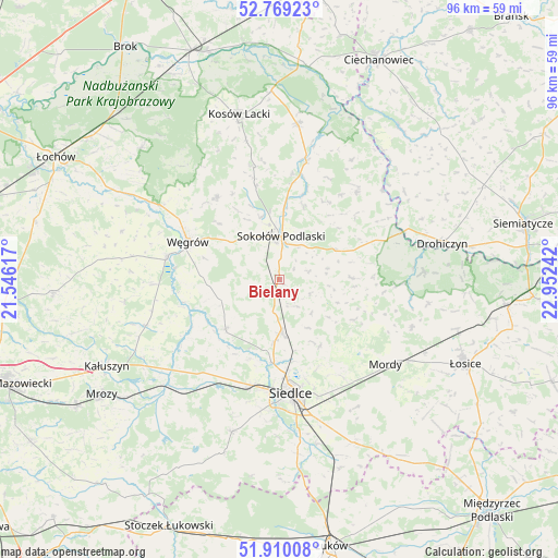
Bielany GPS coordinates[2]
52° 20' 30.264" North, 22° 14' 57.444" East
| Map corner | latitude | longitude |
|---|---|---|
| Upper-left | 52.76923°, | 21.54617° |
| Center: | 52.34174°, | 22.24929° |
| Lower-right: | 51.91008°, | 22.95242° |
| Map W x H: | 95.5×95.5 km | = 59.3×59.3mi |
| max Lat: | 54.83135° ⇑26.5% North |
| Bielany: | 52.34174° |
| min Lat: | ⇓73.5% South 49.21328° |
| min Long | Bielany | max Long |
| 14.20249° | 22.24929° | 24.03723° |
| W 88%⇐ | ⇒12% E |
Elevation
Elevation of Bielany is 158 m = 518 ft, and this is 33.4 m = 110 ft below average elevation for this country.
| Max E: |
974 m = 3196 ft | 55.3% |
| Avg. | 191.4 m = 628 ft | |
| Bielany | 158 m = 518 ft | |
Min E: |
-3 m = -10 ft | 44.7% |
See also: Poland elevation on elevation.city.
Geographical zone
Bielany is located in North temperate zone (between Tropic of Cancer and the Arctic Circle). Distance of this North polar circle is 1581.3 km =982.6 mi to North.| Distance of | km | miles | from Bielany |
|---|---|---|---|
| North Pole | 4187.2 | 2601.8 | to North |
| Arctic Circle | 1581.3 | 982.6 | to North |
| Tropic Cancer | 3213.9 | 1997 | to South |
| Equator | 5819.9 | 3616.3 | to South |


Nearby cities:
15 places around Bielany: (largest is in red/bold)
• Grębków
24.4 km =15.2 mi,  250°
250°
• Jabłonna Lacka
19.9 km =12.4 mi,  41°
41°
• Kotuń
22.1 km =13.7 mi,  213°
213°
• Liw
19.5 km =12.1 mi,  280°
280°
• Miedzna
17.7 km =11 mi,  322°
322°
• Mokobody
12.6 km =7.8 mi,  227°
227°
• Mordy
23.3 km =14.5 mi,  128°
128°
• Paprotnia
15.5 km =9.6 mi,  107°
107°
• Przesmyki
24.2 km =15 mi, 109°
• Repki
10.8 km =6.7 mi,  63°
63°
• Sabnie
18.1 km =11.2 mi,  12°
12°
• Siedlce
19.5 km =12.1 mi,  171°
171°
• Sokołów Podlaski
7.2 km =4.5 mi,  2°
2°
• Suchożebry
9.1 km =5.7 mi,  178°
178°
• Węgrów
17.1 km =10.6 mi,  292°
292°
Sources, notices
• [Note1] Compared only with cities in Poland existing in our database
• [Src1] Map data: © OpenStreetMap contributors (CC-BY-SA)
• [Src2] Other city data from geonames.org with taken over terms of usage.
• [Src3] Geographical zone / Annual Mean Temperature by Robert A. Rohde @ Wikipedia
