Sejny geodata
Sejny (Podlasie) is a seat of a third-order administrative division; located in Poland in Europe/Warsaw (GMT+2) time zone. With population of 5,872 people, there are 612 cities with bigger population in this country. Compared to other cities in Poland, 95.3% of cities are located further ↓South; 98.1% of cities are located further ←West and 64.1% of cities have higher elevation than Sejny. Note1


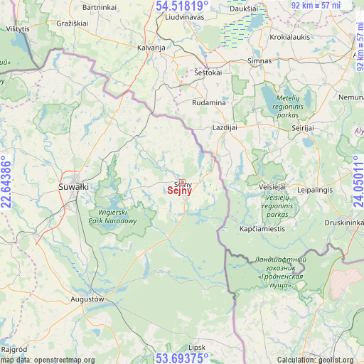
Sejny GPS coordinates[2]
54° 6' 28.872" North, 23° 20' 49.128" East
| Map corner | latitude | longitude |
|---|---|---|
| Upper-left | 54.51819°, | 22.64386° |
| Center: | 54.10802°, | 23.34698° |
| Lower-right: | 53.69375°, | 24.05011° |
| Map W x H: | 91.7×91.7 km | = 57×57mi |
| max Lat: | 54.83135° ⇑4.7% North |
| Sejny: | 54.10802° |
| min Lat: | ⇓95.3% South 49.21328° |
| min Long | Sejny | max Long |
| 14.20249° | 23.34698° | 24.03723° |
| W 98.1%⇐ | ⇒1.9% E |
Elevation
Elevation of Sejny is 136 m = 446 ft, and this is 55.4 m = 182 ft below average elevation for this country.
| Max E: |
974 m = 3196 ft | 64.1% |
| Avg. | 191.4 m = 628 ft | |
| Sejny | 136 m = 446 ft | |
Min E: |
-3 m = -10 ft | 35.9% |
See also: Poland elevation on elevation.city.
Geographical zone
Sejny is located in North temperate zone (between Tropic of Cancer and the Arctic Circle). Distance of this North polar circle is 1384.9 km =860.5 mi to North.| Distance of | km | miles | from Sejny |
|---|---|---|---|
| North Pole | 3990.8 | 2479.8 | to North |
| Arctic Circle | 1384.9 | 860.5 | to North |
| Tropic Cancer | 3410.3 | 2119.1 | to South |
| Equator | 6016.2 | 3738.3 | to South |


Nearby cities:
15 places around Sejny: (largest is in red/bold)
• Augustów
38 km =23.6 mi,  219°
219°
• Bakałarzewo
45.3 km =28.1 mi,  268°
268°
• Bargłów Kościelny
50.6 km =31.4 mi, 222°
• Dąbrowa Białostocka
50.5 km =31.4 mi,  179°
179°
• Filipów
48 km =29.8 mi,  279°
279°
• Giby
7.3 km =4.5 mi, 175°
• Jeleniewo
30.3 km =18.8 mi,  290°
290°
• Krasnopol
9.3 km =5.8 mi, 275°
• Lipsk
41.8 km =26 mi, 175°
• Przerośl
47.6 km =29.6 mi, 289°
• Puńsk
19.2 km =11.9 mi,  325°
325°
• Raczki
39.1 km =24.3 mi,  249°
249°
• Suwałki
27.1 km =16.8 mi, 270°
• Sztabin
50.1 km =31.1 mi,  199°
199°
• Wiżajny
42.4 km =26.3 mi,  312°
312°
Sources, notices
• [Note1] Compared only with cities in Poland existing in our database
• [Src1] Map data: © OpenStreetMap contributors (CC-BY-SA)
• [Src2] Other city data from geonames.org with taken over terms of usage.
• [Src3] Geographical zone / Annual Mean Temperature by Robert A. Rohde @ Wikipedia
