Lipsk geodata
Lipsk (Podlasie) is a seat of a third-order administrative division; located in Poland in Europe/Warsaw (GMT+2) time zone. With population of 2,463 people, there are 1265 cities with bigger population in this country. Compared to other cities in Poland, 91.7% of cities are located further ↓South; 98.5% of cities are located further ←West and 65% of cities have higher elevation than Lipsk. Note1


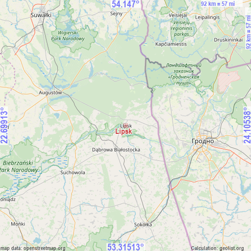
Lipsk GPS coordinates[2]
53° 43' 59.232" North, 23° 24' 8.1" East
| Map corner | latitude | longitude |
|---|---|---|
| Upper-left | 54.147°, | 22.69913° |
| Center: | 53.73312°, | 23.40225° |
| Lower-right: | 53.31513°, | 24.10538° |
| Map W x H: | 92.5×92.5 km | = 57.5×57.5mi |
| max Lat: | 54.83135° ⇑8.3% North |
| Lipsk: | 53.73312° |
| min Lat: | ⇓91.7% South 49.21328° |
| min Long | Lipsk | max Long |
| 14.20249° | 23.40225° | 24.03723° |
| W 98.5%⇐ | ⇒1.5% E |
Elevation
Elevation of Lipsk is 133 m = 436 ft, and this is 58.4 m = 192 ft below average elevation for this country.
| Max E: |
974 m = 3196 ft | 65% |
| Avg. | 191.4 m = 628 ft | |
| Lipsk | 133 m = 436 ft | |
Min E: |
-3 m = -10 ft | 35% |
See also: Poland elevation on elevation.city.
Geographical zone
Lipsk is located in North temperate zone (between Tropic of Cancer and the Arctic Circle). Distance of this North polar circle is 1426.6 km =886.4 mi to North.| Distance of | km | miles | from Lipsk |
|---|---|---|---|
| North Pole | 4032.5 | 2505.7 | to North |
| Arctic Circle | 1426.6 | 886.4 | to North |
| Tropic Cancer | 3368.6 | 2093.2 | to South |
| Equator | 5974.6 | 3712.4 | to South |


Nearby cities:
15 places around Lipsk: (largest is in red/bold)
• Augustów
30.3 km =18.8 mi,  293°
293°
• Bargłów Kościelny
38.4 km =23.9 mi,  276°
276°
• Dąbrowa Białostocka
9.5 km =5.9 mi,  202°
202°
• Giby
34.5 km =21.4 mi,  355°
355°
• Janów
31.6 km =19.6 mi, 200°
• Jaświły
41.1 km =25.5 mi,  226°
226°
• Korycin
38.1 km =23.7 mi,  212°
212°
• Krasnopol
44.5 km =27.7 mi,  343°
343°
• Kuźnica
29.6 km =18.4 mi,  146°
146°
• Nowy Dwór
14.6 km =9.1 mi,  140°
140°
• Sejny
41.8 km =26 mi, 355°
• Sidra
20.3 km =12.6 mi,  171°
171°
• Sokółka
36.8 km =22.9 mi, 169°
• Suchowola
26.1 km =16.2 mi, 228°
• Sztabin
20.8 km =12.9 mi,  254°
254°
Sources, notices
• [Note1] Compared only with cities in Poland existing in our database
• [Src1] Map data: © OpenStreetMap contributors (CC-BY-SA)
• [Src2] Other city data from geonames.org with taken over terms of usage.
• [Src3] Geographical zone / Annual Mean Temperature by Robert A. Rohde @ Wikipedia
