Bargłów Kościelny geodata
Bargłów Kościelny (Podlasie) is a populated place; located in Poland in Europe/Warsaw (GMT+2) time zone. With population of 800 people, there are 2851 cities with bigger population in this country. Compared to other cities in Poland, 92.1% of cities are located further ↓South; 94.7% of cities are located further ←West and 67.1% of cities have higher elevation than Bargłów Kościelny. Note1
Administrative division(s):
- Level 1: Podlasie
- Level 2: Powiat augustowski
- Level 3: Bargłów Kościelny


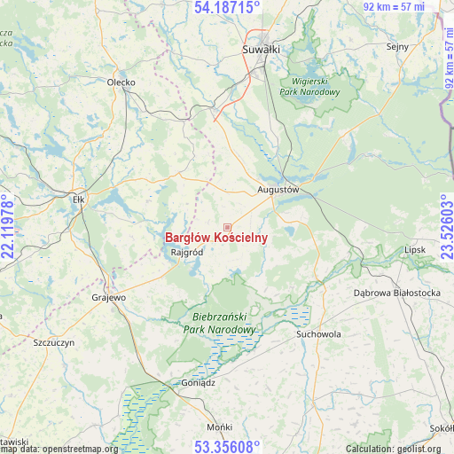
Bargłów Kościelny GPS coordinates[2]
53° 46' 25.212" North, 22° 49' 22.44" East
| Map corner | latitude | longitude |
|---|---|---|
| Upper-left | 54.18715°, | 22.11978° |
| Center: | 53.77367°, | 22.8229° |
| Lower-right: | 53.35608°, | 23.52603° |
| Map W x H: | 92.4×92.4 km | = 57.4×57.4mi |
| max Lat: | 54.83135° ⇑7.9% North |
| Bargłów Kościelny: | 53.77367° |
| min Lat: | ⇓92.1% South 49.21328° |
| min Long | Bargłów Kośc | max Long |
| 14.20249° | 22.8229° | 24.03723° |
| W 94.7%⇐ | ⇒5.3% E |
Elevation
Elevation of Bargłów Kościelny is 128 m = 420 ft, and this is 63.4 m = 208 ft below average elevation for this country.
| Max E: |
974 m = 3196 ft | 67.1% |
| Avg. | 191.4 m = 628 ft | |
| Bargłów Kościelny | 128 m = 420 ft | |
Min E: |
-3 m = -10 ft | 32.9% |
See also: Poland elevation on elevation.city.
Geographical zone
Bargłów Kościelny is located in North temperate zone (between Tropic of Cancer and the Arctic Circle). Distance of this North polar circle is 1422.1 km =883.7 mi to North.| Distance of | km | miles | from Bargłów Kościelny |
|---|---|---|---|
| North Pole | 4028 | 2502.9 | to North |
| Arctic Circle | 1422.1 | 883.7 | to North |
| Tropic Cancer | 3373.2 | 2096 | to South |
| Equator | 5979.1 | 3715.2 | to South |


Nearby cities:
15 places around Bargłów Kościelny: (largest is in red/bold)
• Augustów
12.9 km =8 mi,  53°
53°
• Bakałarzewo
37.3 km =23.2 mi,  342°
342°
• Dąbrowa Białostocka
37 km =23 mi,  111°
111°
• Ełk
30.7 km =19.1 mi,  281°
281°
• Goniadz
32.1 km =19.9 mi,  190°
190°
• Grajewo
28 km =17.4 mi,  239°
239°
• Jaświły
33.7 km =20.9 mi,  165°
165°
• Kalinowo
14.9 km =9.3 mi,  318°
318°
• Olecko
35.6 km =22.1 mi, 324°
• Prostki
27 km =16.8 mi,  252°
252°
• Raczki
23.9 km =14.9 mi,  354°
354°
• Rajgród
9.1 km =5.7 mi, 238°
• Suchowola
28.7 km =17.8 mi,  139°
139°
• Sztabin
20.8 km =12.9 mi,  119°
119°
• Wieliczki
29 km =18 mi, 323°
Sources, notices
• [Note1] Compared only with cities in Poland existing in our database
• [Src1] Map data: © OpenStreetMap contributors (CC-BY-SA)
• [Src2] Other city data from geonames.org with taken over terms of usage.
• [Src3] Geographical zone / Annual Mean Temperature by Robert A. Rohde @ Wikipedia
