Sztabin geodata
Sztabin (Podlasie) is a populated place; located in Poland in Europe/Warsaw (GMT+2) time zone. With population of 920 people, there are 2637 cities with bigger population in this country. Compared to other cities in Poland, 91.3% of cities are located further ↓South; 96.8% of cities are located further ←West and 68.2% of cities have higher elevation than Sztabin. Note1


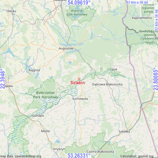
Sztabin GPS coordinates[2]
53° 40' 54.516" North, 23° 5' 51.792" East
| Map corner | latitude | longitude |
|---|---|---|
| Upper-left | 54.09619°, | 22.3946° |
| Center: | 53.68181°, | 23.09772° |
| Lower-right: | 53.26331°, | 23.80085° |
| Map W x H: | 92.6×92.6 km | = 57.5×57.5mi |
| max Lat: | 54.83135° ⇑8.7% North |
| Sztabin: | 53.68181° |
| min Lat: | ⇓91.3% South 49.21328° |
| min Long | Sztabin | max Long |
| 14.20249° | 23.09772° | 24.03723° |
| W 96.8%⇐ | ⇒3.2% E |
Elevation
Elevation of Sztabin is 125 m = 410 ft, and this is 66.4 m = 218 ft below average elevation for this country.
| Max E: |
974 m = 3196 ft | 68.2% |
| Avg. | 191.4 m = 628 ft | |
| Sztabin | 125 m = 410 ft | |
Min E: |
-3 m = -10 ft | 31.8% |
See also: Poland elevation on elevation.city.
Geographical zone
Sztabin is located in North temperate zone (between Tropic of Cancer and the Arctic Circle). Distance of this North polar circle is 1432.3 km =890 mi to North.| Distance of | km | miles | from Sztabin |
|---|---|---|---|
| North Pole | 4038.2 | 2509.2 | to North |
| Arctic Circle | 1432.3 | 890 | to North |
| Tropic Cancer | 3362.9 | 2089.6 | to South |
| Equator | 5968.9 | 3708.9 | to South |


Nearby cities:
15 places around Sztabin: (largest is in red/bold)
• Augustów
19.5 km =12.1 mi,  336°
336°
• Bargłów Kościelny
20.8 km =12.9 mi,  299°
299°
• Dąbrowa Białostocka
16.8 km =10.4 mi,  100°
100°
• Goniadz
32.1 km =19.9 mi,  228°
228°
• Janów
25.4 km =15.8 mi,  159°
159°
• Jasionówka
32.1 km =19.9 mi,  187°
187°
• Jaświły
24.5 km =15.2 mi,  203°
203°
• Kalinowo
35.2 km =21.9 mi,  307°
307°
• Korycin
26.3 km =16.3 mi,  181°
181°
• Lipsk
20.8 km =12.9 mi,  74°
74°
• Mońki
36.6 km =22.7 mi,  212°
212°
• Nowy Dwór
29.9 km =18.6 mi, 100°
• Rajgród
26.4 km =16.4 mi,  281°
281°
• Sidra
27.3 km =17 mi,  121°
121°
• Suchowola
11.6 km =7.2 mi, 177°
Sources, notices
• [Note1] Compared only with cities in Poland existing in our database
• [Src1] Map data: © OpenStreetMap contributors (CC-BY-SA)
• [Src2] Other city data from geonames.org with taken over terms of usage.
• [Src3] Geographical zone / Annual Mean Temperature by Robert A. Rohde @ Wikipedia
