Augustów geodata
Augustów (Podlasie) is a seat of a third-order administrative division; located in Poland in Europe/Warsaw (GMT+2) time zone. With population of 29,752 people, there are 165 cities with bigger population in this country. Compared to other cities in Poland, 92.7% of cities are located further ↓South; 96% of cities are located further ←West and 67.1% of cities have higher elevation than Augustów. Note1


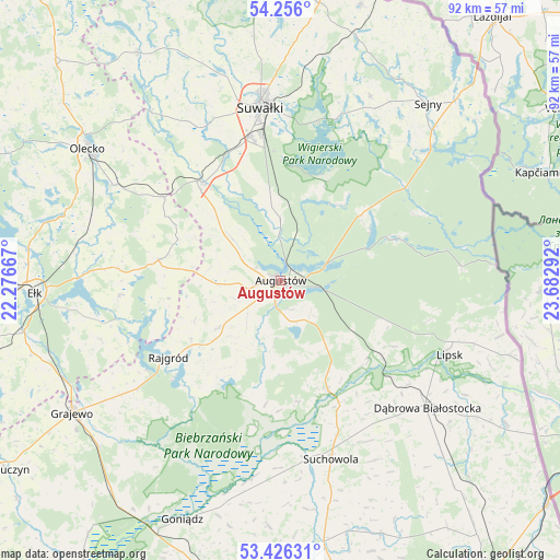
Augustów GPS coordinates[2]
53° 50' 35.556" North, 22° 58' 47.244" East
| Map corner | latitude | longitude |
|---|---|---|
| Upper-left | 54.256°, | 22.27667° |
| Center: | 53.84321°, | 22.97979° |
| Lower-right: | 53.42631°, | 23.68292° |
| Map W x H: | 92.3×92.3 km | = 57.4×57.4mi |
| max Lat: | 54.83135° ⇑7.3% North |
| Augustów: | 53.84321° |
| min Lat: | ⇓92.7% South 49.21328° |
| min Long | Augustów | max Long |
| 14.20249° | 22.97979° | 24.03723° |
| W 96%⇐ | ⇒4% E |
Elevation
Elevation of Augustów is 128 m = 420 ft, and this is 63.4 m = 208 ft below average elevation for this country.
| Max E: |
974 m = 3196 ft | 67.1% |
| Avg. | 191.4 m = 628 ft | |
| Augustów | 128 m = 420 ft | |
Min E: |
-3 m = -10 ft | 32.9% |
See also: Poland elevation on elevation.city.
Geographical zone
Augustów is located in North temperate zone (between Tropic of Cancer and the Arctic Circle). Distance of this North polar circle is 1414.4 km =878.9 mi to North.| Distance of | km | miles | from Augustów |
|---|---|---|---|
| North Pole | 4020.3 | 2498.1 | to North |
| Arctic Circle | 1414.4 | 878.9 | to North |
| Tropic Cancer | 3380.9 | 2100.8 | to South |
| Equator | 5986.8 | 3720 | to South |


Nearby cities:
15 places around Augustów: (largest is in red/bold)
• Bakałarzewo
35.2 km =21.9 mi,  322°
322°
• Bargłów Kościelny
12.9 km =8 mi,  233°
233°
• Dąbrowa Białostocka
32.1 km =19.9 mi,  131°
131°
• Giby
33.1 km =20.6 mi,  48°
48°
• Kalinowo
20.5 km =12.7 mi,  279°
279°
• Krasnopol
33.7 km =20.9 mi,  25°
25°
• Lipsk
30.3 km =18.8 mi,  113°
113°
• Olecko
37.5 km =23.3 mi,  304°
304°
• Raczki
20.5 km =12.7 mi, 321°
• Rajgród
21.9 km =13.6 mi,  235°
235°
• Sejny
38 km =23.6 mi,  39°
39°
• Suchowola
30.7 km =19.1 mi,  164°
164°
• Suwałki
30 km =18.6 mi,  353°
353°
• Sztabin
19.5 km =12.1 mi, 156°
• Wieliczki
31.6 km =19.6 mi, 299°
Sources, notices
• [Note1] Compared only with cities in Poland existing in our database
• [Src1] Map data: © OpenStreetMap contributors (CC-BY-SA)
• [Src2] Other city data from geonames.org with taken over terms of usage.
• [Src3] Geographical zone / Annual Mean Temperature by Robert A. Rohde @ Wikipedia
