Miedzna geodata
Miedzna (Mazovia) is a seat of a third-order administrative division; located in Poland in Europe/Warsaw (GMT+2) time zone. With population of 1,400 people, there are 1959 cities with bigger population in this country. Compared to other cities in Poland, 75.9% of cities are located further ↓South; 85.9% of cities are located further ←West and 58.7% of cities have higher elevation than Miedzna. Note1


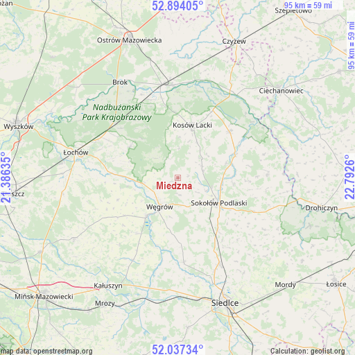
Miedzna GPS coordinates[2]
52° 28' 4.008" North, 22° 5' 22.092" East
| Map corner | latitude | longitude |
|---|---|---|
| Upper-left | 52.89405°, | 21.38635° |
| Center: | 52.46778°, | 22.08947° |
| Lower-right: | 52.03734°, | 22.7926° |
| Map W x H: | 95.3×95.3 km | = 59.2×59.2mi |
| max Lat: | 54.83135° ⇑24.1% North |
| Miedzna: | 52.46778° |
| min Lat: | ⇓75.9% South 49.21328° |
| min Long | Miedzna | max Long |
| 14.20249° | 22.08947° | 24.03723° |
| W 85.9%⇐ | ⇒14.1% E |
Elevation
Elevation of Miedzna is 149 m = 489 ft, and this is 42.4 m = 139 ft below average elevation for this country.
| Max E: |
974 m = 3196 ft | 58.7% |
| Avg. | 191.4 m = 628 ft | |
| Miedzna | 149 m = 489 ft | |
Min E: |
-3 m = -10 ft | 41.3% |
See also: Poland elevation on elevation.city.
Geographical zone
Miedzna is located in North temperate zone (between Tropic of Cancer and the Arctic Circle). Distance of this North polar circle is 1567.3 km =973.9 mi to North.| Distance of | km | miles | from Miedzna |
|---|---|---|---|
| North Pole | 4173.2 | 2593.1 | to North |
| Arctic Circle | 1567.3 | 973.9 | to North |
| Tropic Cancer | 3228 | 2005.8 | to South |
| Equator | 5833.9 | 3625 | to South |


Nearby cities:
15 places around Miedzna: (largest is in red/bold)
• Bielany
17.7 km =11 mi,  142°
142°
• Ceranów
20.4 km =12.7 mi,  27°
27°
• Jabłonna Lacka
23.9 km =14.9 mi,  87°
87°
• Korytnica
17.3 km =10.7 mi,  249°
249°
• Kosów Lacki
14.7 km =9.1 mi,  15°
15°
• Liw
13.2 km =8.2 mi,  218°
218°
• Mokobody
22.6 km =14 mi,  176°
176°
• Ostrówek
24.2 km =15 mi,  293°
293°
• Repki
22.4 km =13.9 mi,  114°
114°
• Sabnie
15.2 km =9.4 mi,  75°
75°
• Sokołów Podlaski
13 km =8.1 mi,  121°
121°
• Sterdyń
18.6 km =11.6 mi,  47°
47°
• Stoczek
15.3 km =9.5 mi,  303°
303°
• Wierzbno
23.5 km =14.6 mi, 221°
• Węgrów
9.1 km =5.7 mi,  213°
213°
Sources, notices
• [Note1] Compared only with cities in Poland existing in our database
• [Src1] Map data: © OpenStreetMap contributors (CC-BY-SA)
• [Src2] Other city data from geonames.org with taken over terms of usage.
• [Src3] Geographical zone / Annual Mean Temperature by Robert A. Rohde @ Wikipedia
