Młynarze geodata
Młynarze (Mazovia) is a seat of a third-order administrative division; located in Poland in Europe/Warsaw (GMT+2) time zone. With population of 227 people, there are 3639 cities with bigger population in this country. Compared to other cities in Poland, 83% of cities are located further ↓South; 78.1% of cities are located further ←West and 83.2% of cities have higher elevation than Młynarze. Note1


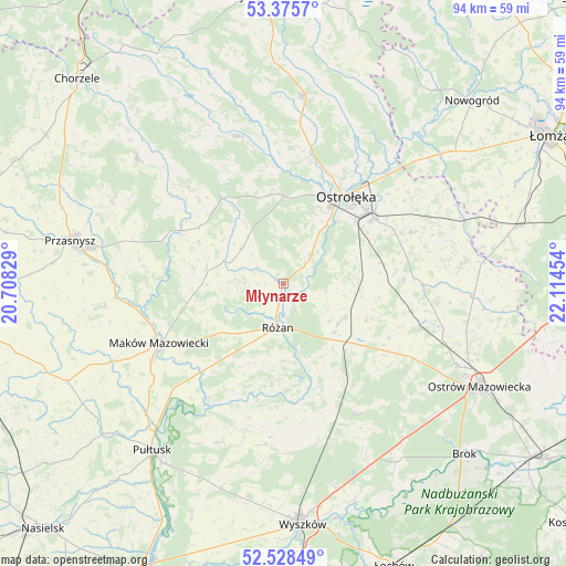
Młynarze GPS coordinates[2]
52° 57' 15.012" North, 21° 24' 41.076" East
| Map corner | latitude | longitude |
|---|---|---|
| Upper-left | 53.3757°, | 20.70829° |
| Center: | 52.95417°, | 21.41141° |
| Lower-right: | 52.52849°, | 22.11454° |
| Map W x H: | 94.2×94.2 km | = 58.5×58.5mi |
| max Lat: | 54.83135° ⇑17% North |
| Młynarze: | 52.95417° |
| min Lat: | ⇓83% South 49.21328° |
| min Long | Młynarze | max Long |
| 14.20249° | 21.41141° | 24.03723° |
| W 78.1%⇐ | ⇒21.9% E |
Elevation
Elevation of Młynarze is 93 m = 305 ft, and this is 98.4 m = 323 ft below average elevation for this country.
| Max E: |
974 m = 3196 ft | 83.2% |
| Avg. | 191.4 m = 628 ft | |
| Młynarze | 93 m = 305 ft | |
Min E: |
-3 m = -10 ft | 16.8% |
See also: Poland elevation on elevation.city.
Geographical zone
Młynarze is located in North temperate zone (between Tropic of Cancer and the Arctic Circle). Distance of this North polar circle is 1513.2 km =940.3 mi to North.| Distance of | km | miles | from Młynarze |
|---|---|---|---|
| North Pole | 4119.1 | 2559.5 | to North |
| Arctic Circle | 1513.2 | 940.3 | to North |
| Tropic Cancer | 3282 | 2039.3 | to South |
| Equator | 5888 | 3658.6 | to South |


Nearby cities:
15 places around Młynarze: (largest is in red/bold)
• Czerwin
23.3 km =14.5 mi,  91°
91°
• Czerwonka
14.8 km =9.2 mi,  242°
242°
• Goworowo
11.3 km =7 mi,  121°
121°
• Krasnosielc
19.2 km =11.9 mi,  297°
297°
• Maków Mazowiecki
23.1 km =14.4 mi, 244°
• Olszewo Borki
15.1 km =9.4 mi,  33°
33°
• Ostrołęka
18.3 km =11.4 mi,  36°
36°
• Płoniawy-Bramura
22.9 km =14.2 mi,  276°
276°
• Rzekuń
17.4 km =10.8 mi,  53°
53°
• Rzewnie
14.2 km =8.8 mi,  200°
200°
• Różan
7.5 km =4.7 mi,  190°
190°
• Sypniewo
9 km =5.6 mi,  309°
309°
• Szelków
18.6 km =11.6 mi,  224°
224°
• Troszyn
23 km =14.3 mi,  68°
68°
• Wąsewo
19.7 km =12.2 mi, 116°
Sources, notices
• [Note1] Compared only with cities in Poland existing in our database
• [Src1] Map data: © OpenStreetMap contributors (CC-BY-SA)
• [Src2] Other city data from geonames.org with taken over terms of usage.
• [Src3] Geographical zone / Annual Mean Temperature by Robert A. Rohde @ Wikipedia
