Goworowo geodata
Goworowo (Mazovia) is a seat of a third-order administrative division; located in Poland in Europe/Warsaw (GMT+2) time zone. With population of 820 people, there are 2819 cities with bigger population in this country. Compared to other cities in Poland, 82.4% of cities are located further ↓South; 79.7% of cities are located further ←West and 81.2% of cities have higher elevation than Goworowo. Note1


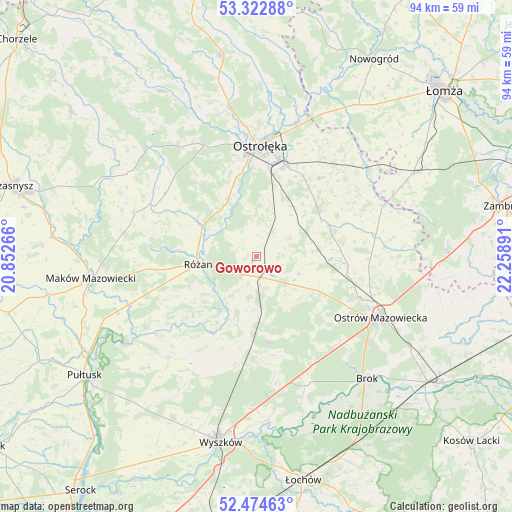
Goworowo GPS coordinates[2]
52° 54' 2.988" North, 21° 33' 20.808" East
| Map corner | latitude | longitude |
|---|---|---|
| Upper-left | 53.32288°, | 20.85266° |
| Center: | 52.90083°, | 21.55578° |
| Lower-right: | 52.47463°, | 22.25891° |
| Map W x H: | 94.3×94.3 km | = 58.6×58.6mi |
| max Lat: | 54.83135° ⇑17.6% North |
| Goworowo: | 52.90083° |
| min Lat: | ⇓82.4% South 49.21328° |
| min Long | Goworowo | max Long |
| 14.20249° | 21.55578° | 24.03723° |
| W 79.7%⇐ | ⇒20.3% E |
Elevation
Elevation of Goworowo is 97 m = 318 ft, and this is 94.4 m = 310 ft below average elevation for this country.
| Max E: |
974 m = 3196 ft | 81.2% |
| Avg. | 191.4 m = 628 ft | |
| Goworowo | 97 m = 318 ft | |
Min E: |
-3 m = -10 ft | 18.8% |
See also: Poland elevation on elevation.city.
Geographical zone
Goworowo is located in North temperate zone (between Tropic of Cancer and the Arctic Circle). Distance of this North polar circle is 1519.2 km =944 mi to North.| Distance of | km | miles | from Goworowo |
|---|---|---|---|
| North Pole | 4125 | 2563.2 | to North |
| Arctic Circle | 1519.2 | 944 | to North |
| Tropic Cancer | 3276.1 | 2035.7 | to South |
| Equator | 5882 | 3654.9 | to South |


Nearby cities:
15 places around Goworowo: (largest is in red/bold)
• Czerwin
14.6 km =9.1 mi,  68°
68°
• Czerwonka
22.9 km =14.2 mi,  267°
267°
• Długosiodło
15.8 km =9.8 mi,  171°
171°
• Młynarze
11.3 km =7 mi,  301°
301°
• Olszewo Borki
18.6 km =11.6 mi,  355°
355°
• Ostrołęka
20.7 km =12.9 mi,  3°
3°
• Ostrów Mazowiecka
25.3 km =15.7 mi,  115°
115°
• Rzekuń
16.9 km =10.5 mi,  14°
14°
• Rzewnie
16.4 km =10.2 mi,  243°
243°
• Rząśnik
24.4 km =15.2 mi,  211°
211°
• Różan
11.1 km =6.9 mi,  262°
262°
• Sypniewo
20.3 km =12.6 mi,  305°
305°
• Szelków
23.8 km =14.8 mi,  252°
252°
• Troszyn
18.6 km =11.6 mi,  38°
38°
• Wąsewo
8.4 km =5.2 mi,  110°
110°
Sources, notices
• [Note1] Compared only with cities in Poland existing in our database
• [Src1] Map data: © OpenStreetMap contributors (CC-BY-SA)
• [Src2] Other city data from geonames.org with taken over terms of usage.
• [Src3] Geographical zone / Annual Mean Temperature by Robert A. Rohde @ Wikipedia
