Kadzidło geodata
Kadzidło (Mazovia) is a seat of a third-order administrative division; located in Poland in Europe/Warsaw (GMT+2) time zone. With population of 4,210 people, there are 777 cities with bigger population in this country. Compared to other cities in Poland, 86.7% of cities are located further ↓South; 78.8% of cities are located further ←West and 70.4% of cities have higher elevation than Kadzidło. Note1


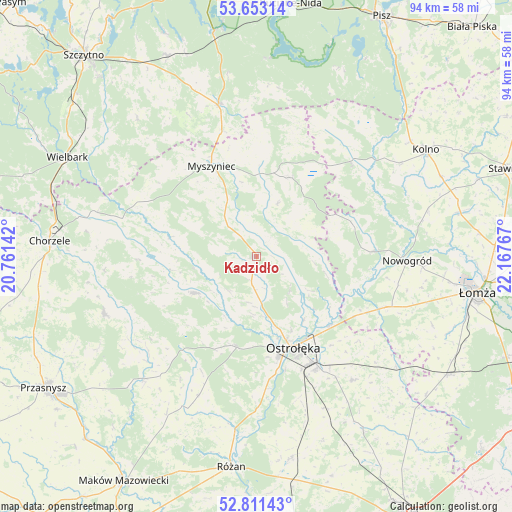
Kadzidło GPS coordinates[2]
53° 14' 3.66" North, 21° 27' 52.344" East
| Map corner | latitude | longitude |
|---|---|---|
| Upper-left | 53.65314°, | 20.76142° |
| Center: | 53.23435°, | 21.46454° |
| Lower-right: | 52.81143°, | 22.16767° |
| Map W x H: | 93.6×93.6 km | = 58.2×58.2mi |
| max Lat: | 54.83135° ⇑13.3% North |
| Kadzidło: | 53.23435° |
| min Lat: | ⇓86.7% South 49.21328° |
| min Long | Kadzidło | max Long |
| 14.20249° | 21.46454° | 24.03723° |
| W 78.8%⇐ | ⇒21.2% E |
Elevation
Elevation of Kadzidło is 120 m = 394 ft, and this is 71.4 m = 234 ft below average elevation for this country.
| Max E: |
974 m = 3196 ft | 70.4% |
| Avg. | 191.4 m = 628 ft | |
| Kadzidło | 120 m = 394 ft | |
Min E: |
-3 m = -10 ft | 29.6% |
See also: Poland elevation on elevation.city.
Geographical zone
Kadzidło is located in North temperate zone (between Tropic of Cancer and the Arctic Circle). Distance of this North polar circle is 1482.1 km =920.9 mi to North.| Distance of | km | miles | from Kadzidło |
|---|---|---|---|
| North Pole | 4088 | 2540.2 | to North |
| Arctic Circle | 1482.1 | 920.9 | to North |
| Tropic Cancer | 3313.2 | 2058.7 | to South |
| Equator | 5919.1 | 3678 | to South |


Nearby cities:
15 places around Kadzidło: (largest is in red/bold)
• Baranowo
12.9 km =8 mi,  239°
239°
• Czarnia
22.4 km =13.9 mi,  307°
307°
• Jednorożec
29.4 km =18.3 mi,  249°
249°
• Lelis
8.6 km =5.3 mi,  133°
133°
• Miastkowo
25.2 km =15.7 mi,  111°
111°
• Myszyniec
18 km =11.2 mi,  334°
334°
• Nowogród
27.8 km =17.3 mi,  91°
91°
• Olszewo Borki
19.1 km =11.9 mi,  165°
165°
• Ostrołęka
18.1 km =11.2 mi,  155°
155°
• Rozogi
28.7 km =17.8 mi,  346°
346°
• Rzekuń
23.2 km =14.4 mi,  153°
153°
• Sypniewo
27.5 km =17.1 mi,  202°
202°
• Troszyn
28.7 km =17.8 mi,  141°
141°
• Zbójna
21.6 km =13.4 mi, 87°
• Łyse
15.9 km =9.9 mi,  24°
24°
Sources, notices
• [Note1] Compared only with cities in Poland existing in our database
• [Src1] Map data: © OpenStreetMap contributors (CC-BY-SA)
• [Src2] Other city data from geonames.org with taken over terms of usage.
• [Src3] Geographical zone / Annual Mean Temperature by Robert A. Rohde @ Wikipedia
