Szynwałd geodata
Szynwałd (Lesser Poland) is a populated place; located in Poland in Europe/Warsaw (GMT+2) time zone. With population of 3,114 people, there are 1012 cities with bigger population in this country. Compared to other cities in Poland, 84.5% of cities are located further ↑North; 74.8% of cities are located further ←West and 76% of cities have lower elevation than Szynwałd. Note1


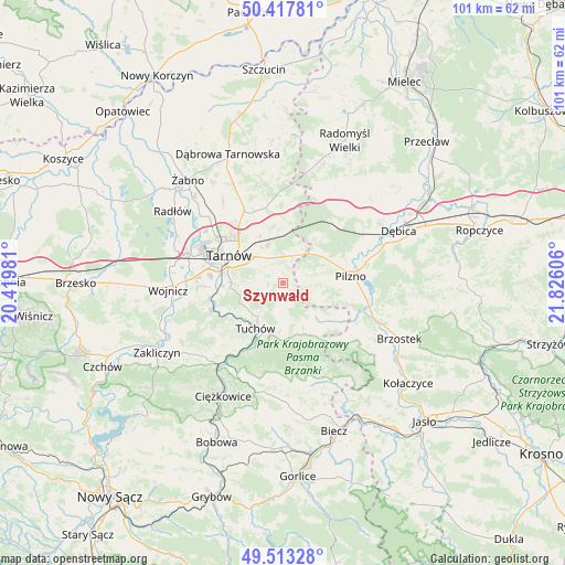
Szynwałd GPS coordinates[2]
49° 58' 3.612" North, 21° 7' 22.548" East
| Map corner | latitude | longitude |
|---|---|---|
| Upper-left | 50.41781°, | 20.41981° |
| Center: | 49.96767°, | 21.12293° |
| Lower-right: | 49.51328°, | 21.82606° |
| Map W x H: | 100.6×100.6 km | = 62.5×62.5mi |
| max Lat: | 54.83135° ⇑84.5% North |
| Szynwałd: | 49.96767° |
| min Lat: | ⇓15.5% South 49.21328° |
| min Long | Szynwałd | max Long |
| 14.20249° | 21.12293° | 24.03723° |
| W 74.8%⇐ | ⇒25.2% E |
Elevation
Elevation of Szynwałd is 250 m = 820 ft, and this is 58.6 m = 192 ft above average elevation for this country.
| Max E: |
974 m = 3196 ft | 24% |
| Szynwałd | 250 m 820 ft | |
| Avg. | 191.4 m = 628 ft | |
Min E: |
-3 m = -10 ft | 76% |
See also: Poland elevation on elevation.city.
Geographical zone
Szynwałd is located in North temperate zone (between Tropic of Cancer and the Arctic Circle). Distance of this North polar circle is 1845.3 km =1146.6 mi to North.| Distance of | km | miles | from Szynwałd |
|---|---|---|---|
| North Pole | 4451.2 | 2765.8 | to North |
| Arctic Circle | 1845.3 | 1146.6 | to North |
| Tropic Cancer | 2950 | 1833 | to South |
| Equator | 5555.9 | 3452.3 | to South |


Nearby cities:
15 places around Szynwałd: (largest is in red/bold)
• Jodłówka-Wałki
9.2 km =5.7 mi,  4°
4°
• Karwodrza
5.8 km =3.6 mi,  217°
217°
• Koszyce
13 km =8.1 mi,  272°
272°
• Koszyce Wielkie
12.8 km =8 mi,  276°
276°
• Lubaszowa
13.5 km =8.4 mi,  207°
207°
• Pilzno
12.2 km =7.6 mi,  84°
84°
• Pogórska Wola
6.2 km =3.9 mi,  23°
23°
• Ryglice
9.9 km =6.2 mi,  173°
173°
• Skrzyszów
5.3 km =3.3 mi,  303°
303°
• Słotowa
12.5 km =7.8 mi,  101°
101°
• Tarnowiec
9.9 km =6.2 mi, 279°
• Tarnów
11 km =6.8 mi, 297°
• Tuchów
9.5 km =5.9 mi, 211°
• Łęki Dolne
8.9 km =5.5 mi,  85°
85°
• Łęki Górne
3.7 km =2.3 mi, 79°
Sources, notices
• [Note1] Compared only with cities in Poland existing in our database
• [Src1] Map data: © OpenStreetMap contributors (CC-BY-SA)
• [Src2] Other city data from geonames.org with taken over terms of usage.
• [Src3] Geographical zone / Annual Mean Temperature by Robert A. Rohde @ Wikipedia
