Ryczywół geodata
Ryczywół (Mazovia) is a populated place; located in Poland in Europe/Warsaw (GMT+2) time zone. With population of 1,300 people, there are 2055 cities with bigger population in this country. Compared to other cities in Poland, 59.9% of cities are located further ↓South; 78.3% of cities are located further ←West and 77.2% of cities have higher elevation than Ryczywół. Note1


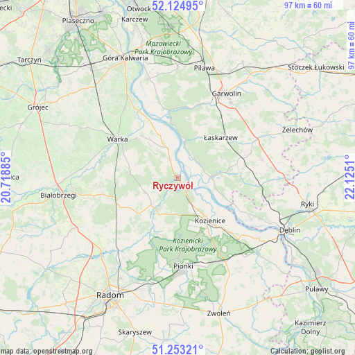
Ryczywół GPS coordinates[2]
51° 41' 28.248" North, 21° 25' 19.092" East
| Map corner | latitude | longitude |
|---|---|---|
| Upper-left | 52.12495°, | 20.71885° |
| Center: | 51.69118°, | 21.42197° |
| Lower-right: | 51.25321°, | 22.1251° |
| Map W x H: | 96.9×96.9 km | = 60.2×60.2mi |
| max Lat: | 54.83135° ⇑40.1% North |
| Ryczywół: | 51.69118° |
| min Lat: | ⇓59.9% South 49.21328° |
| min Long | Ryczywół | max Long |
| 14.20249° | 21.42197° | 24.03723° |
| W 78.3%⇐ | ⇒21.7% E |
Elevation
Elevation of Ryczywół is 105 m = 344 ft, and this is 86.4 m = 283 ft below average elevation for this country.
| Max E: |
974 m = 3196 ft | 77.2% |
| Avg. | 191.4 m = 628 ft | |
| Ryczywół | 105 m = 344 ft | |
Min E: |
-3 m = -10 ft | 22.8% |
See also: Poland elevation on elevation.city.
Geographical zone
Ryczywół is located in North temperate zone (between Tropic of Cancer and the Arctic Circle). Distance of this North polar circle is 1653.7 km =1027.6 mi to North.| Distance of | km | miles | from Ryczywół |
|---|---|---|---|
| North Pole | 4259.5 | 2646.7 | to North |
| Arctic Circle | 1653.7 | 1027.6 | to North |
| Tropic Cancer | 3141.6 | 1952.1 | to South |
| Equator | 5747.5 | 3571.3 | to South |


Nearby cities:
15 places around Ryczywół: (largest is in red/bold)
• Głowaczów
10.4 km =6.5 mi,  223°
223°
• Janików
17.3 km =10.7 mi,  140°
140°
• Kobylnica
11.8 km =7.3 mi,  115°
115°
• Kozienice
14.8 km =9.2 mi, 144°
• Maciejowice
9.1 km =5.7 mi,  89°
89°
• Magnuszew
8.7 km =5.4 mi,  340°
340°
• Paprotnia
17.9 km =11.1 mi,  111°
111°
• Podebłocie
22.9 km =14.2 mi,  104°
104°
• Podlesie Duże
19.7 km =12.2 mi,  249°
249°
• Rębków
22.5 km =14 mi,  23°
23°
• Sobolew
17.4 km =10.8 mi,  73°
73°
• Stromiec
23.3 km =14.5 mi,  257°
257°
• Warka
19 km =11.8 mi,  303°
303°
• Wilga
18.2 km =11.3 mi,  350°
350°
• Łaskarzew
16 km =9.9 mi,  46°
46°
Sources, notices
• [Note1] Compared only with cities in Poland existing in our database
• [Src1] Map data: © OpenStreetMap contributors (CC-BY-SA)
• [Src2] Other city data from geonames.org with taken over terms of usage.
• [Src3] Geographical zone / Annual Mean Temperature by Robert A. Rohde @ Wikipedia
