Paprotnia geodata
Paprotnia (Lublin) is a populated place; located in Poland in Europe/Warsaw (GMT+2) time zone. With population of 585 people, there are 3323 cities with bigger population in this country. Compared to other cities in Poland, 58.6% of cities are located further ↓South; 80.8% of cities are located further ←West and 75.4% of cities have higher elevation than Paprotnia. Note1


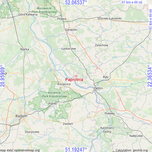
Paprotnia GPS coordinates[2]
51° 37' 51.672" North, 21° 39' 43.956" East
| Map corner | latitude | longitude |
|---|---|---|
| Upper-left | 52.06537°, | 20.95909° |
| Center: | 51.63102°, | 21.66221° |
| Lower-right: | 51.19247°, | 22.36534° |
| Map W x H: | 97.1×97.1 km | = 60.3×60.3mi |
| max Lat: | 54.83135° ⇑41.4% North |
| Paprotnia: | 51.63102° |
| min Lat: | ⇓58.6% South 49.21328° |
| min Long | Paprotnia | max Long |
| 14.20249° | 21.66221° | 24.03723° |
| W 80.8%⇐ | ⇒19.2% E |
Elevation
Elevation of Paprotnia is 110 m = 361 ft, and this is 81.4 m = 267 ft below average elevation for this country.
| Max E: |
974 m = 3196 ft | 75.4% |
| Avg. | 191.4 m = 628 ft | |
| Paprotnia | 110 m = 361 ft | |
Min E: |
-3 m = -10 ft | 24.6% |
See also: Poland elevation on elevation.city.
Geographical zone
Paprotnia is located in North temperate zone (between Tropic of Cancer and the Arctic Circle). Distance of this North polar circle is 1660.3 km =1031.7 mi to North.| Distance of | km | miles | from Paprotnia |
|---|---|---|---|
| North Pole | 4266.2 | 2650.9 | to North |
| Arctic Circle | 1660.3 | 1031.7 | to North |
| Tropic Cancer | 3134.9 | 1947.9 | to South |
| Equator | 5740.8 | 3567.2 | to South |


Nearby cities:
15 places around Paprotnia: (largest is in red/bold)
• Dęblin
15.1 km =9.4 mi,  121°
121°
• Garbatka-Letnisko
16.8 km =10.4 mi,  192°
192°
• Gniewoszów
20.3 km =12.6 mi,  149°
149°
• Janików
8.7 km =5.4 mi,  219°
219°
• Kobylnica
6.1 km =3.8 mi,  285°
285°
• Kozienice
9.5 km =5.9 mi,  235°
235°
• Maciejowice
10.1 km =6.3 mi,  312°
312°
• Podebłocie
5.8 km =3.6 mi,  79°
79°
• Policzna
19.7 km =12.2 mi, 187°
• Ryczywół
17.9 km =11.1 mi, 291°
• Ryki
18.7 km =11.6 mi,  91°
91°
• Sobolew
11.7 km =7.3 mi,  0°
0°
• Stężyca
9.3 km =5.8 mi,  126°
126°
• Trojanów
12.3 km =7.6 mi,  56°
56°
• Łaskarzew
18.3 km =11.4 mi,  344°
344°
Sources, notices
• [Note1] Compared only with cities in Poland existing in our database
• [Src1] Map data: © OpenStreetMap contributors (CC-BY-SA)
• [Src2] Other city data from geonames.org with taken over terms of usage.
• [Src3] Geographical zone / Annual Mean Temperature by Robert A. Rohde @ Wikipedia
