Kobylnica geodata
Kobylnica (Mazovia) is a populated place; located in Poland in Europe/Warsaw (GMT+2) time zone. With population of 522 people, there are 3477 cities with bigger population in this country. Compared to other cities in Poland, 59% of cities are located further ↓South; 79.9% of cities are located further ←West and 76.9% of cities have higher elevation than Kobylnica. Note1


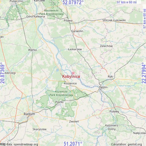
Kobylnica GPS coordinates[2]
51° 38' 43.836" North, 21° 34' 36.516" East
| Map corner | latitude | longitude |
|---|---|---|
| Upper-left | 52.07972°, | 20.87369° |
| Center: | 51.64551°, | 21.57681° |
| Lower-right: | 51.2071°, | 22.27994° |
| Map W x H: | 97×97 km | = 60.3×60.3mi |
| max Lat: | 54.83135° ⇑41% North |
| Kobylnica: | 51.64551° |
| min Lat: | ⇓59% South 49.21328° |
| min Long | Kobylnica | max Long |
| 14.20249° | 21.57681° | 24.03723° |
| W 79.9%⇐ | ⇒20.1% E |
Elevation
Elevation of Kobylnica is 106 m = 348 ft, and this is 85.4 m = 280 ft below average elevation for this country.
| Max E: |
974 m = 3196 ft | 76.9% |
| Avg. | 191.4 m = 628 ft | |
| Kobylnica | 106 m = 348 ft | |
Min E: |
-3 m = -10 ft | 23.1% |
See also: Poland elevation on elevation.city.
Geographical zone
Kobylnica is located in North temperate zone (between Tropic of Cancer and the Arctic Circle). Distance of this North polar circle is 1658.7 km =1030.7 mi to North.| Distance of | km | miles | from Kobylnica |
|---|---|---|---|
| North Pole | 4264.6 | 2649.9 | to North |
| Arctic Circle | 1658.7 | 1030.7 | to North |
| Tropic Cancer | 3136.5 | 1948.9 | to South |
| Equator | 5742.4 | 3568.2 | to South |


Nearby cities:
15 places around Kobylnica: (largest is in red/bold)
• Dęblin
21.1 km =13.1 mi,  117°
117°
• Garbatka-Letnisko
18.2 km =11.3 mi,  172°
172°
• Głowaczów
18 km =11.2 mi,  262°
262°
• Janików
8.3 km =5.2 mi,  177°
177°
• Kozienice
7.2 km =4.5 mi,  196°
196°
• Maciejowice
5.4 km =3.4 mi,  342°
342°
• Magnuszew
19 km =11.8 mi,  314°
314°
• Paprotnia
6.1 km =3.8 mi,  105°
105°
• Pionki
20.8 km =12.9 mi, 204°
• Podebłocie
11.6 km =7.2 mi,  92°
92°
• Ryczywół
11.8 km =7.3 mi,  295°
295°
• Sobolew
11.8 km =7.3 mi,  30°
30°
• Stężyca
15.2 km =9.4 mi, 117°
• Trojanów
17 km =10.6 mi,  72°
72°
• Łaskarzew
16.1 km =10 mi,  3°
3°
Sources, notices
• [Note1] Compared only with cities in Poland existing in our database
• [Src1] Map data: © OpenStreetMap contributors (CC-BY-SA)
• [Src2] Other city data from geonames.org with taken over terms of usage.
• [Src3] Geographical zone / Annual Mean Temperature by Robert A. Rohde @ Wikipedia
