Warka geodata
Warka (Mazovia) is a seat of a third-order administrative division; located in Poland in Europe/Warsaw (GMT+2) time zone. With population of 11,048 people, there are 415 cities with bigger population in this country. Compared to other cities in Poland, 61.8% of cities are located further ↓South; 75.6% of cities are located further ←West and 73.1% of cities have higher elevation than Warka. Note1


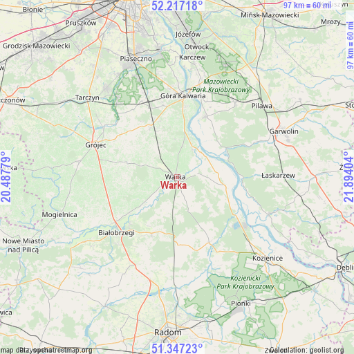
Warka GPS coordinates[2]
51° 47' 3.48" North, 21° 11' 27.276" East
| Map corner | latitude | longitude |
|---|---|---|
| Upper-left | 52.21718°, | 20.48779° |
| Center: | 51.7843°, | 21.19091° |
| Lower-right: | 51.34723°, | 21.89404° |
| Map W x H: | 96.7×96.7 km | = 60.1×60.1mi |
| max Lat: | 54.83135° ⇑38.2% North |
| Warka: | 51.7843° |
| min Lat: | ⇓61.8% South 49.21328° |
| min Long | Warka | max Long |
| 14.20249° | 21.19091° | 24.03723° |
| W 75.6%⇐ | ⇒24.4% E |
Elevation
Elevation of Warka is 115 m = 377 ft, and this is 76.4 m = 251 ft below average elevation for this country.
| Max E: |
974 m = 3196 ft | 73.1% |
| Avg. | 191.4 m = 628 ft | |
| Warka | 115 m = 377 ft | |
Min E: |
-3 m = -10 ft | 26.9% |
See also: Poland elevation on elevation.city.
Geographical zone
Warka is located in North temperate zone (between Tropic of Cancer and the Arctic Circle). Distance of this North polar circle is 1643.3 km =1021.1 mi to North.| Distance of | km | miles | from Warka |
|---|---|---|---|
| North Pole | 4249.2 | 2640.3 | to North |
| Arctic Circle | 1643.3 | 1021.1 | to North |
| Tropic Cancer | 3152 | 1958.6 | to South |
| Equator | 5757.9 | 3577.8 | to South |


Nearby cities:
15 places around Warka: (largest is in red/bold)
• Białobrzegi
22.5 km =14 mi,  227°
227°
• Chynów
15.3 km =9.5 mi,  330°
330°
• Czersk
19.6 km =12.2 mi,  8°
8°
• Góra Kalwaria
21.4 km =13.3 mi,  4°
4°
• Głowaczów
19.9 km =12.4 mi,  153°
153°
• Jasieniec
17.7 km =11 mi,  283°
283°
• Magnuszew
13.2 km =8.2 mi,  99°
99°
• Podlesie Duże
17.5 km =10.9 mi,  188°
188°
• Prażmów
23.8 km =14.8 mi,  316°
316°
• Promna
19.7 km =12.2 mi, 234°
• Ryczywół
19 km =11.8 mi,  123°
123°
• Sobienie Jeziory
18.2 km =11.3 mi,  25°
25°
• Stromiec
16.7 km =10.4 mi,  203°
203°
• Sułkowice
16.9 km =10.5 mi,  335°
335°
• Wilga
14.9 km =9.3 mi,  59°
59°
Sources, notices
• [Note1] Compared only with cities in Poland existing in our database
• [Src1] Map data: © OpenStreetMap contributors (CC-BY-SA)
• [Src2] Other city data from geonames.org with taken over terms of usage.
• [Src3] Geographical zone / Annual Mean Temperature by Robert A. Rohde @ Wikipedia
