Podebłocie geodata
Podebłocie (Mazovia) is a populated place; located in Poland in Europe/Warsaw (GMT+2) time zone. With population of 1,025 people, there are 2424 cities with bigger population in this country. Compared to other cities in Poland, 58.9% of cities are located further ↓South; 81.6% of cities are located further ←West and 59.5% of cities have higher elevation than Podebłocie. Note1


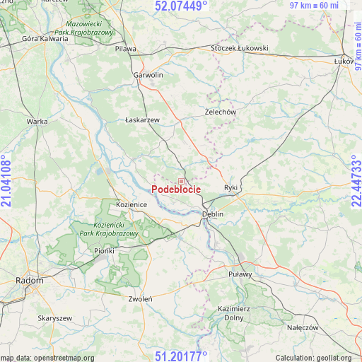
Podebłocie GPS coordinates[2]
51° 38' 24.828" North, 21° 44' 39.12" East
| Map corner | latitude | longitude |
|---|---|---|
| Upper-left | 52.07449°, | 21.04108° |
| Center: | 51.64023°, | 21.7442° |
| Lower-right: | 51.20177°, | 22.44733° |
| Map W x H: | 97×97 km | = 60.3×60.3mi |
| max Lat: | 54.83135° ⇑41.1% North |
| Podebłocie: | 51.64023° |
| min Lat: | ⇓58.9% South 49.21328° |
| min Long | Podebłocie | max Long |
| 14.20249° | 21.7442° | 24.03723° |
| W 81.6%⇐ | ⇒18.4% E |
Elevation
Elevation of Podebłocie is 148 m = 486 ft, and this is 43.4 m = 142 ft below average elevation for this country.
| Max E: |
974 m = 3196 ft | 59.5% |
| Avg. | 191.4 m = 628 ft | |
| Podebłocie | 148 m = 486 ft | |
Min E: |
-3 m = -10 ft | 40.5% |
See also: Poland elevation on elevation.city.
Geographical zone
Podebłocie is located in North temperate zone (between Tropic of Cancer and the Arctic Circle). Distance of this North polar circle is 1659.3 km =1031 mi to North.| Distance of | km | miles | from Podebłocie |
|---|---|---|---|
| North Pole | 4265.2 | 2650.3 | to North |
| Arctic Circle | 1659.3 | 1031 | to North |
| Tropic Cancer | 3135.9 | 1948.6 | to South |
| Equator | 5741.9 | 3567.9 | to South |


Nearby cities:
15 places around Podebłocie: (largest is in red/bold)
• Bobrowniki
16.5 km =10.3 mi,  127°
127°
• Dęblin
11.5 km =7.1 mi,  141°
141°
• Gniewoszów
19.1 km =11.9 mi,  165°
165°
• Janików
13.6 km =8.5 mi,  235°
235°
• Kawęczyn
19.5 km =12.1 mi,  65°
65°
• Kobylnica
11.6 km =7.2 mi,  272°
272°
• Kozienice
15 km =9.3 mi, 244°
• Kłoczew
17.7 km =11 mi,  59°
59°
• Maciejowice
14.4 km =8.9 mi,  293°
293°
• Moszczanka
15.9 km =9.9 mi,  106°
106°
• Paprotnia
5.8 km =3.6 mi,  259°
259°
• Ryki
13.1 km =8.1 mi,  97°
97°
• Sobolew
12.1 km =7.5 mi,  332°
332°
• Stężyca
6.7 km =4.2 mi,  164°
164°
• Trojanów
7.4 km =4.6 mi,  38°
38°
Sources, notices
• [Note1] Compared only with cities in Poland existing in our database
• [Src1] Map data: © OpenStreetMap contributors (CC-BY-SA)
• [Src2] Other city data from geonames.org with taken over terms of usage.
• [Src3] Geographical zone / Annual Mean Temperature by Robert A. Rohde @ Wikipedia
