Magnuszew geodata
Magnuszew (Mazovia) is a populated place; located in Poland in Europe/Warsaw (GMT+2) time zone. With population of 800 people, there are 2851 cities with bigger population in this country. Compared to other cities in Poland, 61.3% of cities are located further ↓South; 77.8% of cities are located further ←West and 79.3% of cities have higher elevation than Magnuszew. Note1


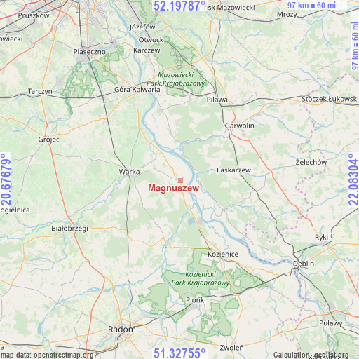
Magnuszew GPS coordinates[2]
51° 45' 53.316" North, 21° 22' 47.676" East
| Map corner | latitude | longitude |
|---|---|---|
| Upper-left | 52.19787°, | 20.67679° |
| Center: | 51.76481°, | 21.37991° |
| Lower-right: | 51.32755°, | 22.08304° |
| Map W x H: | 96.8×96.8 km | = 60.1×60.1mi |
| max Lat: | 54.83135° ⇑38.7% North |
| Magnuszew: | 51.76481° |
| min Lat: | ⇓61.3% South 49.21328° |
| min Long | Magnuszew | max Long |
| 14.20249° | 21.37991° | 24.03723° |
| W 77.8%⇐ | ⇒22.2% E |
Elevation
Elevation of Magnuszew is 101 m = 331 ft, and this is 90.4 m = 297 ft below average elevation for this country.
| Max E: |
974 m = 3196 ft | 79.3% |
| Avg. | 191.4 m = 628 ft | |
| Magnuszew | 101 m = 331 ft | |
Min E: |
-3 m = -10 ft | 20.7% |
See also: Poland elevation on elevation.city.
Geographical zone
Magnuszew is located in North temperate zone (between Tropic of Cancer and the Arctic Circle). Distance of this North polar circle is 1645.5 km =1022.5 mi to North.| Distance of | km | miles | from Magnuszew |
|---|---|---|---|
| North Pole | 4251.4 | 2641.7 | to North |
| Arctic Circle | 1645.5 | 1022.5 | to North |
| Tropic Cancer | 3149.8 | 1957.2 | to South |
| Equator | 5755.7 | 3576.4 | to South |


Nearby cities:
15 places around Magnuszew: (largest is in red/bold)
• Garwolin
21.9 km =13.6 mi,  47°
47°
• Głowaczów
16.3 km =10.1 mi,  195°
195°
• Kobylnica
19 km =11.8 mi,  134°
134°
• Maciejowice
14.4 km =8.9 mi,  124°
124°
• Miętne
21.9 km =13.6 mi,  37°
37°
• Podlesie Duże
21.7 km =13.5 mi,  225°
225°
• Ryczywół
8.7 km =5.4 mi,  160°
160°
• Rębków
17.2 km =10.7 mi, 43°
• Sobienie Jeziory
19.4 km =12.1 mi,  344°
344°
• Sobolew
19.8 km =12.3 mi,  99°
99°
• Sulbiny Górne
21.1 km =13.1 mi,  55°
55°
• Warka
13.2 km =8.2 mi,  279°
279°
• Wilga
9.7 km =6 mi,  359°
359°
• Wola Rębkowska
19.5 km =12.1 mi, 38°
• Łaskarzew
14.8 km =9.2 mi,  79°
79°
Sources, notices
• [Note1] Compared only with cities in Poland existing in our database
• [Src1] Map data: © OpenStreetMap contributors (CC-BY-SA)
• [Src2] Other city data from geonames.org with taken over terms of usage.
• [Src3] Geographical zone / Annual Mean Temperature by Robert A. Rohde @ Wikipedia
