Kowala geodata
Kowala (Mazovia) is a seat of a third-order administrative division; located in Poland in Europe/Warsaw (GMT+2) time zone. With population of 1,023 people, there are 2426 cities with bigger population in this country. Compared to other cities in Poland, 53.7% of cities are located further ↓South; 73.9% of cities are located further ←West and 57.3% of cities have lower elevation than Kowala. Note1


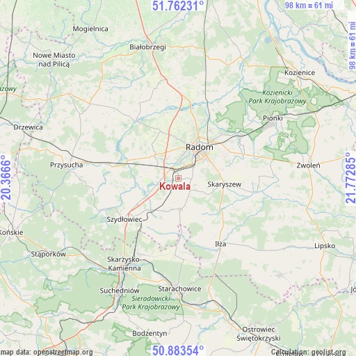
Kowala GPS coordinates[2]
51° 19' 30.108" North, 21° 4' 10.992" East
| Map corner | latitude | longitude |
|---|---|---|
| Upper-left | 51.76231°, | 20.3666° |
| Center: | 51.32503°, | 21.06972° |
| Lower-right: | 50.88354°, | 21.77285° |
| Map W x H: | 97.7×97.7 km | = 60.7×60.7mi |
| max Lat: | 54.83135° ⇑46.3% North |
| Kowala: | 51.32503° |
| min Lat: | ⇓53.7% South 49.21328° |
| min Long | Kowala | max Long |
| 14.20249° | 21.06972° | 24.03723° |
| W 73.9%⇐ | ⇒26.1% E |
Elevation
Elevation of Kowala is 191 m = 627 ft, and this is 0.40000000000001 m = 1 ft below average elevation for this country.
| Max E: |
974 m = 3196 ft | 42.7% |
| Avg. | 191.4 m = 628 ft | |
| Kowala | 191 m = 627 ft | |
Min E: |
-3 m = -10 ft | 57.3% |
See also: Poland elevation on elevation.city.
Geographical zone
Kowala is located in North temperate zone (between Tropic of Cancer and the Arctic Circle). Distance of this North polar circle is 1694.4 km =1052.9 mi to North.| Distance of | km | miles | from Kowala |
|---|---|---|---|
| North Pole | 4300.3 | 2672.1 | to North |
| Arctic Circle | 1694.4 | 1052.9 | to North |
| Tropic Cancer | 3100.9 | 1926.8 | to South |
| Equator | 5706.8 | 3546 | to South |


Nearby cities:
15 places around Kowala: (largest is in red/bold)
• Jastrząb
12.1 km =7.5 mi,  224°
224°
• Ludwinów
3.1 km =1.9 mi,  34°
34°
• Maków
12.9 km =8 mi,  79°
79°
• Mazowszany
4.9 km =3 mi,  70°
70°
• Mirów
14.4 km =8.9 mi,  190°
190°
• Orońsko
5.6 km =3.5 mi,  256°
256°
• Radom
10.2 km =6.3 mi, 31°
• Rogów
14.7 km =9.1 mi,  196°
196°
• Rzeczków
6.5 km =4 mi, 185°
• Skaryszew
12.8 km =8 mi,  97°
97°
• Sławno
8 km =5 mi,  329°
329°
• Trablice
5.1 km =3.2 mi,  53°
53°
• Wierzbica
8.5 km =5.3 mi,  173°
173°
• Wolanów
8.9 km =5.5 mi,  313°
313°
• Zakrzew
13.7 km =8.5 mi,  339°
339°
Sources, notices
• [Note1] Compared only with cities in Poland existing in our database
• [Src1] Map data: © OpenStreetMap contributors (CC-BY-SA)
• [Src2] Other city data from geonames.org with taken over terms of usage.
• [Src3] Geographical zone / Annual Mean Temperature by Robert A. Rohde @ Wikipedia
