Wierzbica geodata
Wierzbica (Mazovia) is a seat of a third-order administrative division; located in Poland in Europe/Warsaw (GMT+2) time zone. With population of 3,956 people, there are 826 cities with bigger population in this country. Compared to other cities in Poland, 52.1% of cities are located further ↓South; 74.1% of cities are located further ←West and 61% of cities have lower elevation than Wierzbica. Note1


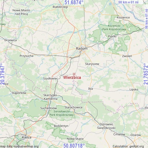
Wierzbica GPS coordinates[2]
51° 14' 57.84" North, 21° 4' 57.324" East
| Map corner | latitude | longitude |
|---|---|---|
| Upper-left | 51.6874°, | 20.37947° |
| Center: | 51.2494°, | 21.08259° |
| Lower-right: | 50.80718°, | 21.78572° |
| Map W x H: | 97.9×97.9 km | = 60.8×60.8mi |
| max Lat: | 54.83135° ⇑47.9% North |
| Wierzbica: | 51.2494° |
| min Lat: | ⇓52.1% South 49.21328° |
| min Long | Wierzbica | max Long |
| 14.20249° | 21.08259° | 24.03723° |
| W 74.1%⇐ | ⇒25.9% E |
Elevation
Elevation of Wierzbica is 203 m = 666 ft, and this is 11.6 m = 38 ft above average elevation for this country.
| Max E: |
974 m = 3196 ft | 39% |
| Wierzbica | 203 m 666 ft | |
| Avg. | 191.4 m = 628 ft | |
Min E: |
-3 m = -10 ft | 61% |
See also: Poland elevation on elevation.city.
Geographical zone
Wierzbica is located in North temperate zone (between Tropic of Cancer and the Arctic Circle). Distance of this North polar circle is 1702.8 km =1058.1 mi to North.| Distance of | km | miles | from Wierzbica |
|---|---|---|---|
| North Pole | 4308.7 | 2677.3 | to North |
| Arctic Circle | 1702.8 | 1058.1 | to North |
| Tropic Cancer | 3092.5 | 1921.6 | to South |
| Equator | 5698.4 | 3540.8 | to South |


Nearby cities:
15 places around Wierzbica: (largest is in red/bold)
• Grzybowa Góra
15.4 km =9.6 mi,  213°
213°
• Iłża
14.6 km =9.1 mi,  131°
131°
• Jastrząb
9.4 km =5.8 mi,  268°
268°
• Kowala
8.5 km =5.3 mi,  353°
353°
• Ludwinów
11 km =6.8 mi,  4°
4°
• Mazowszany
10.7 km =6.6 mi,  20°
20°
• Mirzec
12.9 km =8 mi,  187°
187°
• Mirów
6.8 km =4.2 mi, 210°
• Mirów Stary
7.6 km =4.7 mi,  201°
201°
• Orońsko
9.6 km =6 mi,  318°
318°
• Pakosław
9.1 km =5.7 mi, 134°
• Rogów
7.7 km =4.8 mi,  222°
222°
• Rzeczków
2.5 km =1.6 mi, 321°
• Skaryszew
13.6 km =8.5 mi,  59°
59°
• Trablice
11.9 km =7.4 mi, 15°
Sources, notices
• [Note1] Compared only with cities in Poland existing in our database
• [Src1] Map data: © OpenStreetMap contributors (CC-BY-SA)
• [Src2] Other city data from geonames.org with taken over terms of usage.
• [Src3] Geographical zone / Annual Mean Temperature by Robert A. Rohde @ Wikipedia
