Smyków geodata
Smyków (Lesser Poland) is a populated place; located in Poland in Europe/Warsaw (GMT+2) time zone. With population of 627 people, there are 3215 cities with bigger population in this country. Compared to other cities in Poland, 76.3% of cities are located further ↑North; 74.8% of cities are located further ←West and 62.2% of cities have lower elevation than Smyków. Note1


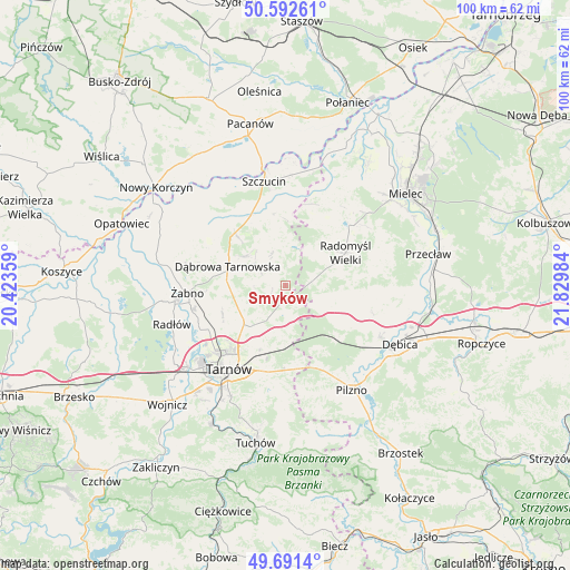
Smyków GPS coordinates[2]
50° 8' 38.868" North, 21° 7' 36.156" East
| Map corner | latitude | longitude |
|---|---|---|
| Upper-left | 50.59261°, | 20.42359° |
| Center: | 50.14413°, | 21.12671° |
| Lower-right: | 49.6914°, | 21.82984° |
| Map W x H: | 100.2×100.2 km | = 62.3×62.3mi |
| max Lat: | 54.83135° ⇑76.3% North |
| Smyków: | 50.14413° |
| min Lat: | ⇓23.7% South 49.21328° |
| min Long | Smyków | max Long |
| 14.20249° | 21.12671° | 24.03723° |
| W 74.8%⇐ | ⇒25.2% E |
Elevation
Elevation of Smyków is 206 m = 676 ft, and this is 14.6 m = 48 ft above average elevation for this country.
| Max E: |
974 m = 3196 ft | 37.8% |
| Smyków | 206 m 676 ft | |
| Avg. | 191.4 m = 628 ft | |
Min E: |
-3 m = -10 ft | 62.2% |
See also: Poland elevation on elevation.city.
Geographical zone
Smyków is located in North temperate zone (between Tropic of Cancer and the Arctic Circle). Distance of this North polar circle is 1825.7 km =1134.4 mi to North.| Distance of | km | miles | from Smyków |
|---|---|---|---|
| North Pole | 4431.6 | 2753.7 | to North |
| Arctic Circle | 1825.7 | 1134.4 | to North |
| Tropic Cancer | 2969.6 | 1845.2 | to South |
| Equator | 5575.5 | 3464.5 | to South |


Nearby cities:
15 places around Smyków: (largest is in red/bold)
• Czarna
12.6 km =7.8 mi,  132°
132°
• Dąbrowa Tarnowska
10.6 km =6.6 mi,  288°
288°
• Gruszów Wielki
8.6 km =5.3 mi,  307°
307°
• Jodłówka-Wałki
10.5 km =6.5 mi,  177°
177°
• Lisia Góra
9.2 km =5.7 mi,  219°
219°
• Niedomice
17 km =10.6 mi,  256°
256°
• Odporyszów
15.3 km =9.5 mi,  273°
273°
• Olesno
15.7 km =9.8 mi, 294°
• Pogórska Wola
14.1 km =8.8 mi,  170°
170°
• Radgoszcz
6.9 km =4.3 mi,  351°
351°
• Radomyśl Wielki
12.2 km =7.6 mi,  61°
61°
• Sieradza
14.1 km =8.8 mi, 265°
• Smęgorzów
12.8 km =8 mi,  317°
317°
• Swarzów
13.4 km =8.3 mi, 294°
• Łukowa
12.2 km =7.6 mi,  242°
242°
Sources, notices
• [Note1] Compared only with cities in Poland existing in our database
• [Src1] Map data: © OpenStreetMap contributors (CC-BY-SA)
• [Src2] Other city data from geonames.org with taken over terms of usage.
• [Src3] Geographical zone / Annual Mean Temperature by Robert A. Rohde @ Wikipedia
