Lisia Góra geodata
Lisia Góra (Lesser Poland) is a seat of a third-order administrative division; located in Poland in Europe/Warsaw (GMT+2) time zone. With population of 3,019 people, there are 1035 cities with bigger population in this country. Compared to other cities in Poland, 78.9% of cities are located further ↑North; 73.4% of cities are located further ←West and 74.5% of cities have lower elevation than Lisia Góra. Note1


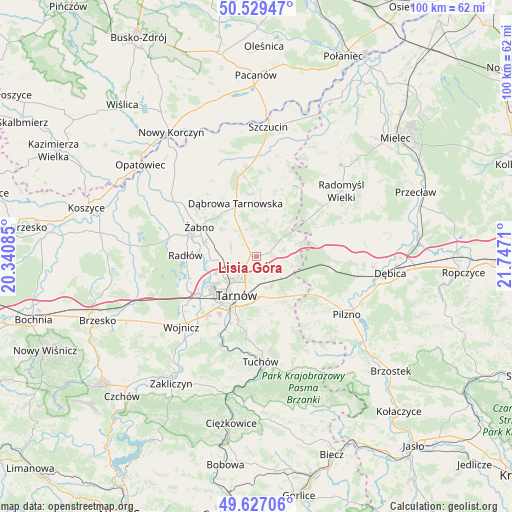
Lisia Góra GPS coordinates[2]
50° 4' 49.404" North, 21° 2' 38.292" East
| Map corner | latitude | longitude |
|---|---|---|
| Upper-left | 50.52947°, | 20.34085° |
| Center: | 50.08039°, | 21.04397° |
| Lower-right: | 49.62706°, | 21.7471° |
| Map W x H: | 100.3×100.3 km | = 62.3×62.3mi |
| max Lat: | 54.83135° ⇑78.9% North |
| Lisia Góra: | 50.08039° |
| min Lat: | ⇓21.1% South 49.21328° |
| min Long | Lisia Góra | max Long |
| 14.20249° | 21.04397° | 24.03723° |
| W 73.4%⇐ | ⇒26.6% E |
Elevation
Elevation of Lisia Góra is 244 m = 801 ft, and this is 52.6 m = 173 ft above average elevation for this country.
| Max E: |
974 m = 3196 ft | 25.5% |
| Lisia Góra | 244 m 801 ft | |
| Avg. | 191.4 m = 628 ft | |
Min E: |
-3 m = -10 ft | 74.5% |
See also: Poland elevation on elevation.city.
Geographical zone
Lisia Góra is located in North temperate zone (between Tropic of Cancer and the Arctic Circle). Distance of this North polar circle is 1832.8 km =1138.8 mi to North.| Distance of | km | miles | from Lisia Góra |
|---|---|---|---|
| North Pole | 4438.6 | 2758 | to North |
| Arctic Circle | 1832.8 | 1138.8 | to North |
| Tropic Cancer | 2962.5 | 1840.8 | to South |
| Equator | 5568.4 | 3460 | to South |


Nearby cities:
15 places around Lisia Góra: (largest is in red/bold)
• Dąbrowa Tarnowska
11.3 km =7 mi,  338°
338°
• Gruszów Wielki
12.4 km =7.7 mi,  355°
355°
• Jodłówka-Wałki
7.2 km =4.5 mi,  117°
117°
• Koszyce Wielkie
13.1 km =8.1 mi,  212°
212°
• Niedomice
11 km =6.8 mi,  285°
285°
• Odporyszów
12.3 km =7.6 mi,  310°
310°
• Pogórska Wola
10.7 km =6.6 mi,  130°
130°
• Sieradza
10.2 km =6.3 mi, 306°
• Skrzyszów
9.7 km =6 mi,  172°
172°
• Smyków
9.2 km =5.7 mi,  39°
39°
• Szynwałd
13.7 km =8.5 mi,  155°
155°
• Tarnowiec
11.7 km =7.3 mi,  200°
200°
• Tarnów
8.4 km =5.2 mi, 208°
• Łukowa
5.1 km =3.2 mi, 286°
• Żabno
12.7 km =7.9 mi,  297°
297°
Sources, notices
• [Note1] Compared only with cities in Poland existing in our database
• [Src1] Map data: © OpenStreetMap contributors (CC-BY-SA)
• [Src2] Other city data from geonames.org with taken over terms of usage.
• [Src3] Geographical zone / Annual Mean Temperature by Robert A. Rohde @ Wikipedia
