Przyborów geodata
Przyborów (Subcarpathian) is a populated place; located in Poland in Europe/Warsaw (GMT+2) time zone. With population of 746 people, there are 2984 cities with bigger population in this country. Compared to other cities in Poland, 80.9% of cities are located further ↑North; 77.5% of cities are located further ←West and 56.8% of cities have lower elevation than Przyborów. Note1


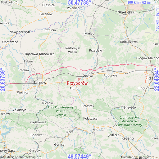
Przyborów GPS coordinates[2]
50° 1' 41.916" North, 21° 20' 25.836" East
| Map corner | latitude | longitude |
|---|---|---|
| Upper-left | 50.47788°, | 20.63739° |
| Center: | 50.02831°, | 21.34051° |
| Lower-right: | 49.57449°, | 22.04364° |
| Map W x H: | 100.4×100.4 km | = 62.4×62.4mi |
| max Lat: | 54.83135° ⇑80.9% North |
| Przyborów: | 50.02831° |
| min Lat: | ⇓19.1% South 49.21328° |
| min Long | Przyborów | max Long |
| 14.20249° | 21.34051° | 24.03723° |
| W 77.5%⇐ | ⇒22.5% E |
Elevation
Elevation of Przyborów is 190 m = 623 ft, and this is 1.4 m = 5 ft below average elevation for this country.
| Max E: |
974 m = 3196 ft | 43.2% |
| Avg. | 191.4 m = 628 ft | |
| Przyborów | 190 m = 623 ft | |
Min E: |
-3 m = -10 ft | 56.8% |
See also: Poland elevation on elevation.city.
Geographical zone
Przyborów is located in North temperate zone (between Tropic of Cancer and the Arctic Circle). Distance of this North polar circle is 1838.5 km =1142.4 mi to North.| Distance of | km | miles | from Przyborów |
|---|---|---|---|
| North Pole | 4444.4 | 2761.6 | to North |
| Arctic Circle | 1838.5 | 1142.4 | to North |
| Tropic Cancer | 2956.7 | 1837.2 | to South |
| Equator | 5562.6 | 3456.4 | to South |


Nearby cities:
15 places around Przyborów: (largest is in red/bold)
• Brzeźnica
12.8 km =8 mi,  51°
51°
• Brzostek
17.3 km =10.7 mi,  163°
163°
• Czarna
7.4 km =4.6 mi,  305°
305°
• Dębica
5.7 km =3.5 mi,  63°
63°
• Jodłowa
17.9 km =11.1 mi,  194°
194°
• Jodłówka-Wałki
15 km =9.3 mi,  279°
279°
• Niedźwiada
13.6 km =8.5 mi,  108°
108°
• Pilzno
6.5 km =4 mi,  212°
212°
• Pogórska Wola
13.1 km =8.1 mi,  265°
265°
• Strzegocice
8.7 km =5.4 mi, 188°
• Szynwałd
17 km =10.6 mi,  246°
246°
• Słotowa
9.7 km =6 mi,  199°
199°
• Łęki Dolne
9 km =5.6 mi,  227°
227°
• Łęki Górne
13.3 km =8.3 mi,  242°
242°
• Żyraków
7.5 km =4.7 mi,  32°
32°
Sources, notices
• [Note1] Compared only with cities in Poland existing in our database
• [Src1] Map data: © OpenStreetMap contributors (CC-BY-SA)
• [Src2] Other city data from geonames.org with taken over terms of usage.
• [Src3] Geographical zone / Annual Mean Temperature by Robert A. Rohde @ Wikipedia
