Jodłówka-Wałki geodata
Jodłówka-Wałki (Lesser Poland) is a populated place; located in Poland in Europe/Warsaw (GMT+2) time zone. With population of 1,119 people, there are 2279 cities with bigger population in this country. Compared to other cities in Poland, 80.1% of cities are located further ↑North; 74.9% of cities are located further ←West and 65.9% of cities have lower elevation than Jodłówka-Wałki. Note1


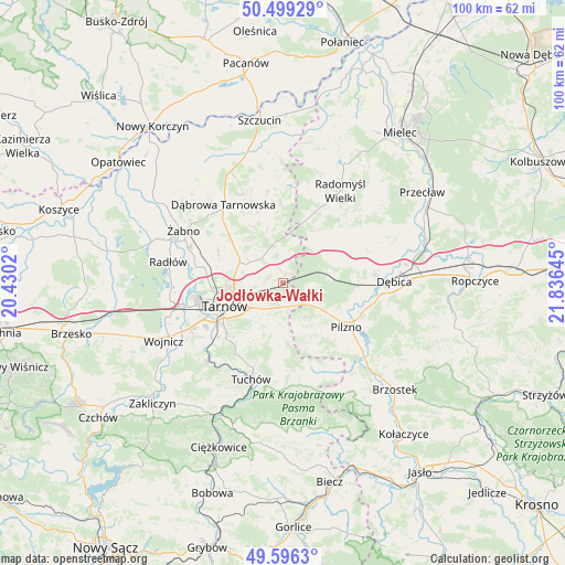
Jodłówka-Wałki GPS coordinates[2]
50° 2' 59.712" North, 21° 7' 59.952" East
| Map corner | latitude | longitude |
|---|---|---|
| Upper-left | 50.49929°, | 20.4302° |
| Center: | 50.04992°, | 21.13332° |
| Lower-right: | 49.5963°, | 21.83645° |
| Map W x H: | 100.4×100.4 km | = 62.4×62.4mi |
| max Lat: | 54.83135° ⇑80.1% North |
| Jodłówka-Wałki: | 50.04992° |
| min Lat: | ⇓19.9% South 49.21328° |
| min Long | Jodłówka-Wał | max Long |
| 14.20249° | 21.13332° | 24.03723° |
| W 74.9%⇐ | ⇒25.1% E |
Elevation
Elevation of Jodłówka-Wałki is 216 m = 709 ft, and this is 24.6 m = 81 ft above average elevation for this country.
| Max E: |
974 m = 3196 ft | 34.1% |
| Jodłówka-Wałki | 216 m 709 ft | |
| Avg. | 191.4 m = 628 ft | |
Min E: |
-3 m = -10 ft | 65.9% |
See also: Poland elevation on elevation.city.
Geographical zone
Jodłówka-Wałki is located in North temperate zone (between Tropic of Cancer and the Arctic Circle). Distance of this North polar circle is 1836.1 km =1140.9 mi to North.| Distance of | km | miles | from Jodłówka-Wałki |
|---|---|---|---|
| North Pole | 4442 | 2760.1 | to North |
| Arctic Circle | 1836.1 | 1140.9 | to North |
| Tropic Cancer | 2959.1 | 1838.7 | to South |
| Equator | 5565 | 3457.9 | to South |


Nearby cities:
15 places around Jodłówka-Wałki: (largest is in red/bold)
• Czarna
9 km =5.6 mi,  77°
77°
• Karwodrza
14.4 km =8.9 mi,  197°
197°
• Koszyce Wielkie
15.5 km =9.6 mi,  240°
240°
• Lisia Góra
7.2 km =4.5 mi,  297°
297°
• Pilzno
13.8 km =8.6 mi,  124°
124°
• Pogórska Wola
3.9 km =2.4 mi,  153°
153°
• Przyborów
15 km =9.3 mi,  99°
99°
• Skrzyszów
8.1 km =5 mi,  219°
219°
• Smyków
10.5 km =6.5 mi,  357°
357°
• Szynwałd
9.2 km =5.7 mi,  184°
184°
• Tarnowiec
12.9 km =8 mi,  234°
234°
• Tarnów
11.2 km =7 mi,  248°
248°
• Łukowa
12.2 km =7.6 mi,  293°
293°
• Łęki Dolne
11.7 km =7.3 mi,  136°
136°
• Łęki Górne
8.9 km =5.5 mi,  160°
160°
Sources, notices
• [Note1] Compared only with cities in Poland existing in our database
• [Src1] Map data: © OpenStreetMap contributors (CC-BY-SA)
• [Src2] Other city data from geonames.org with taken over terms of usage.
• [Src3] Geographical zone / Annual Mean Temperature by Robert A. Rohde @ Wikipedia
