Dębica geodata
Dębica (Subcarpathian) is a seat of a second-order administrative division; located in Poland in Europe/Warsaw (GMT+2) time zone. With population of 47,366 people, there are 109 cities with bigger population in this country. Compared to other cities in Poland, 80% of cities are located further ↑North; 78.1% of cities are located further ←West and 60% of cities have lower elevation than Dębica. Note1


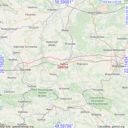
Dębica GPS coordinates[2]
50° 3' 5.256" North, 21° 24' 41.076" East
| Map corner | latitude | longitude |
|---|---|---|
| Upper-left | 50.50081°, | 20.70829° |
| Center: | 50.05146°, | 21.41141° |
| Lower-right: | 49.59786°, | 22.11454° |
| Map W x H: | 100.4×100.4 km | = 62.4×62.4mi |
| max Lat: | 54.83135° ⇑80% North |
| Dębica: | 50.05146° |
| min Lat: | ⇓20% South 49.21328° |
| min Long | Dębica | max Long |
| 14.20249° | 21.41141° | 24.03723° |
| W 78.1%⇐ | ⇒21.9% E |
Elevation
Elevation of Dębica is 200 m = 656 ft, and this is 8.6 m = 28 ft above average elevation for this country.
| Max E: |
974 m = 3196 ft | 40% |
| Dębica | 200 m 656 ft | |
| Avg. | 191.4 m = 628 ft | |
Min E: |
-3 m = -10 ft | 60% |
See also: Dębica elevation on elevation.city.
Geographical zone
Dębica is located in North temperate zone (between Tropic of Cancer and the Arctic Circle). Distance of this North polar circle is 1836 km =1140.8 mi to North.| Distance of | km | miles | from Dębica |
|---|---|---|---|
| North Pole | 4441.9 | 2760.1 | to North |
| Arctic Circle | 1836 | 1140.8 | to North |
| Tropic Cancer | 2959.3 | 1838.8 | to South |
| Equator | 5565.2 | 3458.1 | to South |


Nearby cities:
15 places around Dębica: (largest is in red/bold)
• Brzeźnica
7.4 km =4.6 mi,  41°
41°
• Błonie
18.7 km =11.6 mi,  16°
16°
• Czarna
11.2 km =7 mi,  278°
278°
• Niedźwiada
10.5 km =6.5 mi,  131°
131°
• Ostrów
14 km =8.7 mi,  68°
68°
• Pilzno
11.7 km =7.3 mi,  226°
226°
• Pogórska Wola
18.5 km =11.5 mi,  258°
258°
• Przecław
16.5 km =10.3 mi, 17°
• Przyborów
5.7 km =3.5 mi,  243°
243°
• Ropczyce
14.1 km =8.8 mi,  89°
89°
• Strzegocice
12.8 km =8 mi,  209°
209°
• Słotowa
14.4 km =8.9 mi,  215°
215°
• Wielopole Skrzyńskie
18.7 km =11.6 mi, 128°
• Łęki Dolne
14.6 km =9.1 mi, 233°
• Żyraków
3.9 km =2.4 mi,  343°
343°
Sources, notices
• [Note1] Compared only with cities in Poland existing in our database
• [Src1] Map data: © OpenStreetMap contributors (CC-BY-SA)
• [Src2] Other city data from geonames.org with taken over terms of usage.
• [Src3] Geographical zone / Annual Mean Temperature by Robert A. Rohde @ Wikipedia
