Brzostek geodata
Brzostek (Subcarpathian) is a seat of a third-order administrative division; located in Poland in Europe/Warsaw (GMT+2) time zone. With population of 2,599 people, there are 1209 cities with bigger population in this country. Compared to other cities in Poland, 88.4% of cities are located further ↑North; 78.1% of cities are located further ←West and 69.4% of cities have lower elevation than Brzostek. Note1


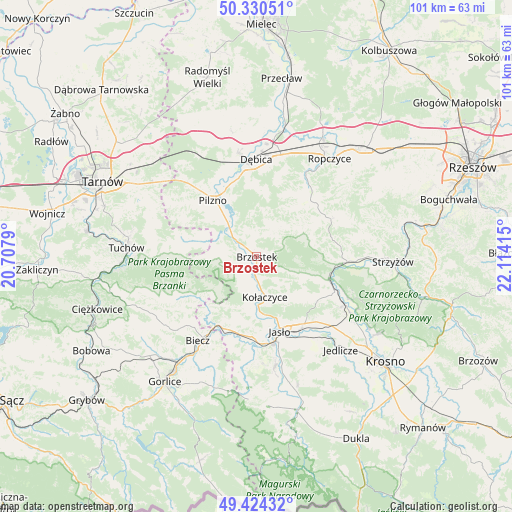
Brzostek GPS coordinates[2]
49° 52' 46.344" North, 21° 24' 39.672" East
| Map corner | latitude | longitude |
|---|---|---|
| Upper-left | 50.33051°, | 20.7079° |
| Center: | 49.87954°, | 21.41102° |
| Lower-right: | 49.42432°, | 22.11415° |
| Map W x H: | 100.8×100.8 km | = 62.6×62.6mi |
| max Lat: | 54.83135° ⇑88.4% North |
| Brzostek: | 49.87954° |
| min Lat: | ⇓11.6% South 49.21328° |
| min Long | Brzostek | max Long |
| 14.20249° | 21.41102° | 24.03723° |
| W 78.1%⇐ | ⇒21.9% E |
Elevation
Elevation of Brzostek is 227 m = 745 ft, and this is 35.6 m = 117 ft above average elevation for this country.
| Max E: |
974 m = 3196 ft | 30.6% |
| Brzostek | 227 m 745 ft | |
| Avg. | 191.4 m = 628 ft | |
Min E: |
-3 m = -10 ft | 69.4% |
See also: Poland elevation on elevation.city.
Geographical zone
Brzostek is located in North temperate zone (between Tropic of Cancer and the Arctic Circle). Distance of this North polar circle is 1855.1 km =1152.7 mi to North.| Distance of | km | miles | from Brzostek |
|---|---|---|---|
| North Pole | 4461 | 2771.9 | to North |
| Arctic Circle | 1855.1 | 1152.7 | to North |
| Tropic Cancer | 2940.2 | 1827 | to South |
| Equator | 5546.1 | 3446.2 | to South |


Nearby cities:
15 places around Brzostek: (largest is in red/bold)
• Brzyska
6.5 km =4 mi,  193°
193°
• Frysztak
14.8 km =9.2 mi,  106°
106°
• Jabłonica
11.2 km =7 mi,  211°
211°
• Jasło
15.6 km =9.7 mi,  163°
163°
• Jodłowa
9.5 km =5.9 mi,  265°
265°
• Kołaczyce
8.2 km =5.1 mi,  168°
168°
• Lipnica Dolna
10.9 km =6.8 mi, 190°
• Niedźwiada
14.6 km =9.1 mi,  32°
32°
• Pilzno
13.9 km =8.6 mi,  322°
322°
• Skołyszyn
15.4 km =9.6 mi,  200°
200°
• Strzegocice
10.2 km =6.3 mi, 321°
• Szerzyny
14.1 km =8.8 mi,  236°
236°
• Słotowa
11.2 km =7 mi,  311°
311°
• Trzcinica
15.2 km =9.4 mi,  178°
178°
• Wróblowa
10 km =6.2 mi, 184°
Sources, notices
• [Note1] Compared only with cities in Poland existing in our database
• [Src1] Map data: © OpenStreetMap contributors (CC-BY-SA)
• [Src2] Other city data from geonames.org with taken over terms of usage.
• [Src3] Geographical zone / Annual Mean Temperature by Robert A. Rohde @ Wikipedia
