Czarna geodata
Czarna (Subcarpathian) is a seat of a third-order administrative division; located in Poland in Europe/Warsaw (GMT+2) time zone. With population of 2,474 people, there are 1260 cities with bigger population in this country. Compared to other cities in Poland, 79.4% of cities are located further ↑North; 76.5% of cities are located further ←West and 61% of cities have lower elevation than Czarna. Note1


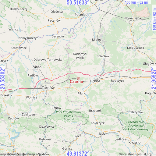
Czarna GPS coordinates[2]
50° 4' 1.812" North, 21° 15' 22.104" East
| Map corner | latitude | longitude |
|---|---|---|
| Upper-left | 50.51638°, | 20.55302° |
| Center: | 50.06717°, | 21.25614° |
| Lower-right: | 49.61372°, | 21.95927° |
| Map W x H: | 100.4×100.4 km | = 62.4×62.4mi |
| max Lat: | 54.83135° ⇑79.4% North |
| Czarna: | 50.06717° |
| min Lat: | ⇓20.6% South 49.21328° |
| min Long | Czarna | max Long |
| 14.20249° | 21.25614° | 24.03723° |
| W 76.5%⇐ | ⇒23.5% E |
Elevation
Elevation of Czarna is 203 m = 666 ft, and this is 11.6 m = 38 ft above average elevation for this country.
| Max E: |
974 m = 3196 ft | 39% |
| Czarna | 203 m 666 ft | |
| Avg. | 191.4 m = 628 ft | |
Min E: |
-3 m = -10 ft | 61% |
See also: Poland elevation on elevation.city.
Geographical zone
Czarna is located in North temperate zone (between Tropic of Cancer and the Arctic Circle). Distance of this North polar circle is 1834.2 km =1139.7 mi to North.| Distance of | km | miles | from Czarna |
|---|---|---|---|
| North Pole | 4440.1 | 2758.9 | to North |
| Arctic Circle | 1834.2 | 1139.7 | to North |
| Tropic Cancer | 2961 | 1839.9 | to South |
| Equator | 5566.9 | 3459.1 | to South |


Nearby cities:
15 places around Czarna: (largest is in red/bold)
• Dębica
11.2 km =7 mi,  98°
98°
• Jodłówka-Wałki
9 km =5.6 mi,  257°
257°
• Lisia Góra
15.2 km =9.4 mi,  275°
275°
• Pilzno
10.2 km =6.3 mi,  165°
165°
• Pogórska Wola
8.9 km =5.5 mi,  232°
232°
• Przyborów
7.4 km =4.6 mi,  125°
125°
• Radomyśl Wielki
14.5 km =9 mi,  5°
5°
• Skrzyszów
16.1 km =10 mi,  239°
239°
• Smyków
12.6 km =7.8 mi,  312°
312°
• Strzegocice
13.7 km =8.5 mi,  159°
159°
• Szynwałd
14.6 km =9.1 mi,  220°
220°
• Słotowa
13.7 km =8.5 mi, 168°
• Łęki Dolne
10.4 km =6.5 mi,  183°
183°
• Łęki Górne
11.9 km =7.4 mi,  209°
209°
• Żyraków
10.2 km =6.3 mi,  78°
78°
Sources, notices
• [Note1] Compared only with cities in Poland existing in our database
• [Src1] Map data: © OpenStreetMap contributors (CC-BY-SA)
• [Src2] Other city data from geonames.org with taken over terms of usage.
• [Src3] Geographical zone / Annual Mean Temperature by Robert A. Rohde @ Wikipedia
