Świerże geodata
Świerże (Lublin) is a populated place; located in Poland in Europe/Warsaw (GMT+2) time zone. With population of 990 people, there are 2509 cities with bigger population in this country. Compared to other cities in Poland, 51.3% of cities are located further ↓South; 99.6% of cities are located further ←West and 50.8% of cities have lower elevation than Świerże. Note1


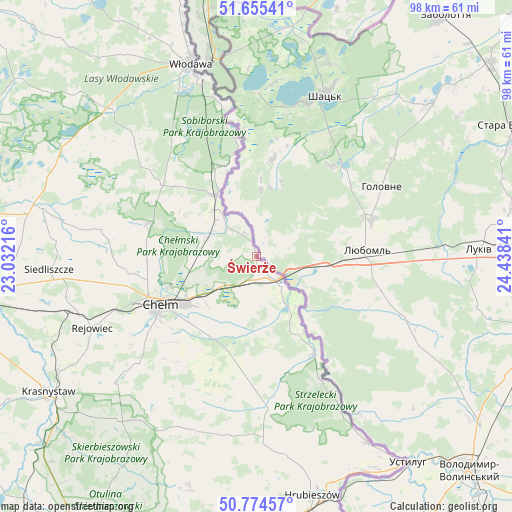
Świerże GPS coordinates[2]
51° 13' 1.56" North, 23° 44' 7.008" East
| Map corner | latitude | longitude |
|---|---|---|
| Upper-left | 51.65541°, | 23.03216° |
| Center: | 51.2171°, | 23.73528° |
| Lower-right: | 50.77457°, | 24.43841° |
| Map W x H: | 97.9×97.9 km | = 60.8×60.8mi |
| max Lat: | 54.83135° ⇑48.7% North |
| Świerże: | 51.2171° |
| min Lat: | ⇓51.3% South 49.21328° |
| min Long | Świerże | max Long |
| 14.20249° | 23.73528° | 24.03723° |
| W 99.6%⇐ | ⇒0.40000000000001% E |
Elevation
Elevation of Świerże is 174 m = 571 ft, and this is 17.4 m = 57 ft below average elevation for this country.
| Max E: |
974 m = 3196 ft | 49.2% |
| Avg. | 191.4 m = 628 ft | |
| Świerże | 174 m = 571 ft | |
Min E: |
-3 m = -10 ft | 50.8% |
See also: Poland elevation on elevation.city.
Geographical zone
Świerże is located in North temperate zone (between Tropic of Cancer and the Arctic Circle). Distance of this North polar circle is 1706.4 km =1060.3 mi to North.| Distance of | km | miles | from Świerże |
|---|---|---|---|
| North Pole | 4312.3 | 2679.5 | to North |
| Arctic Circle | 1706.4 | 1060.3 | to North |
| Tropic Cancer | 3088.9 | 1919.4 | to South |
| Equator | 5694.8 | 3538.6 | to South |


Nearby cities:
15 places around Świerże: (largest is in red/bold)
• Białopole
25.7 km =16 mi,  180°
180°
• Chełm
20.1 km =12.5 mi,  245°
245°
• Dorohusk
8.4 km =5.2 mi,  145°
145°
• Dorohusk-Osada
6.6 km =4.1 mi,  142°
142°
• Dubienka
21.7 km =13.5 mi, 149°
• Hańsk
31.9 km =19.8 mi,  313°
313°
• Jarosławiec
34.5 km =21.4 mi, 184°
• Kamień
17 km =10.6 mi,  217°
217°
• Pokrówka
23.3 km =14.5 mi,  234°
234°
• Rejowiec
34.6 km =21.5 mi, 246°
• Ruda-Huta
10 km =6.2 mi,  282°
282°
• Sawin
21.9 km =13.6 mi,  286°
286°
• Siedliszcze
9.9 km =6.2 mi,  316°
316°
• Wola Uhruska
13.9 km =8.6 mi,  326°
326°
• Żmudź
22.5 km =14 mi,  190°
190°
Sources, notices
• [Note1] Compared only with cities in Poland existing in our database
• [Src1] Map data: © OpenStreetMap contributors (CC-BY-SA)
• [Src2] Other city data from geonames.org with taken over terms of usage.
• [Src3] Geographical zone / Annual Mean Temperature by Robert A. Rohde @ Wikipedia
