Jasieniec geodata
Jasieniec (Mazovia) is a populated place; located in Poland in Europe/Warsaw (GMT+2) time zone. With population of 1,109 people, there are 2295 cities with bigger population in this country. Compared to other cities in Poland, 62.5% of cities are located further ↓South; 71.3% of cities are located further ←West and 63.7% of cities have higher elevation than Jasieniec. Note1


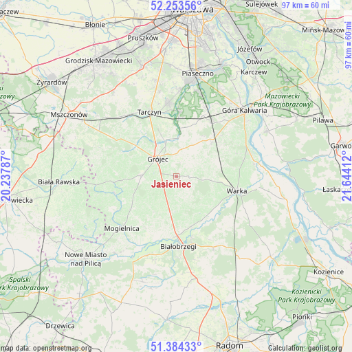
Jasieniec GPS coordinates[2]
51° 49' 15.744" North, 20° 56' 27.564" East
| Map corner | latitude | longitude |
|---|---|---|
| Upper-left | 52.25356°, | 20.23787° |
| Center: | 51.82104°, | 20.94099° |
| Lower-right: | 51.38433°, | 21.64412° |
| Map W x H: | 96.6×96.6 km | = 60×60mi |
| max Lat: | 54.83135° ⇑37.5% North |
| Jasieniec: | 51.82104° |
| min Lat: | ⇓62.5% South 49.21328° |
| min Long | Jasieniec | max Long |
| 14.20249° | 20.94099° | 24.03723° |
| W 71.3%⇐ | ⇒28.7% E |
Elevation
Elevation of Jasieniec is 137 m = 449 ft, and this is 54.4 m = 178 ft below average elevation for this country.
| Max E: |
974 m = 3196 ft | 63.7% |
| Avg. | 191.4 m = 628 ft | |
| Jasieniec | 137 m = 449 ft | |
Min E: |
-3 m = -10 ft | 36.3% |
See also: Poland elevation on elevation.city.
Geographical zone
Jasieniec is located in North temperate zone (between Tropic of Cancer and the Arctic Circle). Distance of this North polar circle is 1639.2 km =1018.6 mi to North.| Distance of | km | miles | from Jasieniec |
|---|---|---|---|
| North Pole | 4245.1 | 2637.8 | to North |
| Arctic Circle | 1639.2 | 1018.6 | to North |
| Tropic Cancer | 3156 | 1961 | to South |
| Equator | 5762 | 3580.3 | to South |


Nearby cities:
15 places around Jasieniec: (largest is in red/bold)
• Belsk Duży
9.1 km =5.7 mi,  273°
273°
• Białobrzegi
19.4 km =12.1 mi,  178°
178°
• Błędów
17.4 km =10.8 mi,  253°
253°
• Chynów
13.4 km =8.3 mi,  46°
46°
• Goszczyn
11.7 km =7.3 mi,  211°
211°
• Grójec
6.8 km =4.2 mi,  312°
312°
• Mogielnica
20.6 km =12.8 mi,  226°
226°
• Pniewy
17 km =10.6 mi, 307°
• Prażmów
13.3 km =8.3 mi,  4°
4°
• Promna
15.7 km =9.8 mi, 175°
• Przybyszew
18.6 km =11.6 mi,  199°
199°
• Stromiec
22 km =13.7 mi,  151°
151°
• Sułkowice
15.2 km =9.4 mi,  41°
41°
• Tarczyn
19.3 km =12 mi,  337°
337°
• Warka
17.7 km =11 mi,  103°
103°
Sources, notices
• [Note1] Compared only with cities in Poland existing in our database
• [Src1] Map data: © OpenStreetMap contributors (CC-BY-SA)
• [Src2] Other city data from geonames.org with taken over terms of usage.
• [Src3] Geographical zone / Annual Mean Temperature by Robert A. Rohde @ Wikipedia
