Oblęgórek geodata
Oblęgórek (Świętokrzyskie) is a populated place; located in Poland in Europe/Warsaw (GMT+2) time zone. With population of 950 people, there are 2592 cities with bigger population in this country. Compared to other cities in Poland, 56.3% of cities are located further ↑North; 64.9% of cities are located further ←West and 82.3% of cities have lower elevation than Oblęgórek. Note1


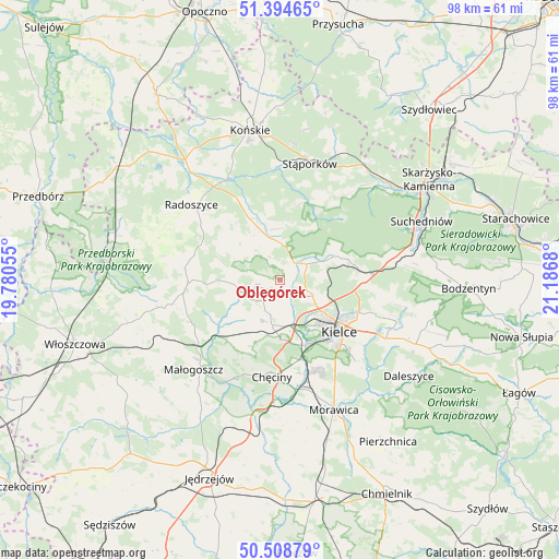
Oblęgórek GPS coordinates[2]
50° 57' 13.788" North, 20° 29' 1.212" East
| Map corner | latitude | longitude |
|---|---|---|
| Upper-left | 51.39465°, | 19.78055° |
| Center: | 50.95383°, | 20.48367° |
| Lower-right: | 50.50879°, | 21.1868° |
| Map W x H: | 98.5×98.5 km | = 61.2×61.2mi |
| max Lat: | 54.83135° ⇑56.3% North |
| Oblęgórek: | 50.95383° |
| min Lat: | ⇓43.7% South 49.21328° |
| min Long | Oblęgórek | max Long |
| 14.20249° | 20.48367° | 24.03723° |
| W 64.9%⇐ | ⇒35.1% E |
Elevation
Elevation of Oblęgórek is 277 m = 909 ft, and this is 85.6 m = 281 ft above average elevation for this country.
| Max E: |
974 m = 3196 ft | 17.7% |
| Oblęgórek | 277 m 909 ft | |
| Avg. | 191.4 m = 628 ft | |
Min E: |
-3 m = -10 ft | 82.3% |
See also: Poland elevation on elevation.city.
Geographical zone
Oblęgórek is located in North temperate zone (between Tropic of Cancer and the Arctic Circle). Distance of this North polar circle is 1735.6 km =1078.5 mi to North.| Distance of | km | miles | from Oblęgórek |
|---|---|---|---|
| North Pole | 4341.5 | 2697.7 | to North |
| Arctic Circle | 1735.6 | 1078.5 | to North |
| Tropic Cancer | 3059.6 | 1901.1 | to South |
| Equator | 5665.5 | 3520.4 | to South |


Nearby cities:
15 places around Oblęgórek: (largest is in red/bold)
• Chęciny
17.1 km =10.6 mi,  185°
185°
• Domaszowice
16.5 km =10.3 mi,  122°
122°
• Kaniów
13.1 km =8.1 mi,  74°
74°
• Kielce
13.7 km =8.5 mi,  132°
132°
• Kostomłoty Drugie
6.5 km =4 mi, 117°
• Kostomłoty Pierwsze
8.5 km =5.3 mi,  113°
113°
• Masłów
17.8 km =11.1 mi, 109°
• Miedziana Góra
5.1 km =3.2 mi, 111°
• Mniów
6.5 km =4 mi,  0°
0°
• Osiedle-Nowiny
15.7 km =9.8 mi,  165°
165°
• Piekoszów
8.3 km =5.2 mi, 189°
• Smyków
11.6 km =7.2 mi,  329°
329°
• Strawczyn
4.6 km =2.9 mi,  252°
252°
• Zagnańsk
12.9 km =8 mi,  76°
76°
• Łopuszno
16.3 km =10.1 mi,  267°
267°
Sources, notices
• [Note1] Compared only with cities in Poland existing in our database
• [Src1] Map data: © OpenStreetMap contributors (CC-BY-SA)
• [Src2] Other city data from geonames.org with taken over terms of usage.
• [Src3] Geographical zone / Annual Mean Temperature by Robert A. Rohde @ Wikipedia
