Domaszowice geodata
Domaszowice (Świętokrzyskie) is a populated place; located in Poland in Europe/Warsaw (GMT+2) time zone. With population of 1,003 people, there are 2455 cities with bigger population in this country. Compared to other cities in Poland, 58.5% of cities are located further ↑North; 67.3% of cities are located further ←West and 83.9% of cities have lower elevation than Domaszowice. Note1


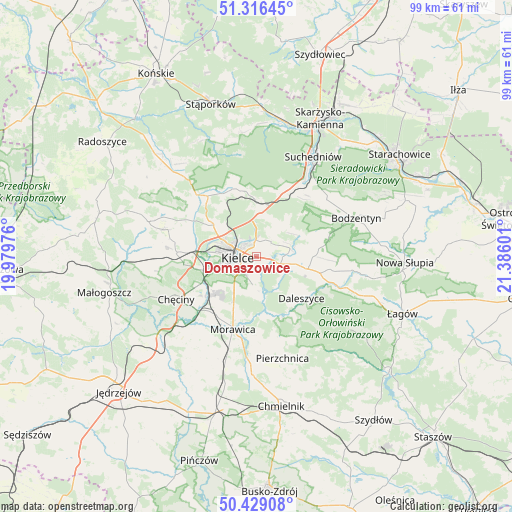
Domaszowice GPS coordinates[2]
50° 52' 29.568" North, 20° 40' 58.368" East
| Map corner | latitude | longitude |
|---|---|---|
| Upper-left | 51.31645°, | 19.97976° |
| Center: | 50.87488°, | 20.68288° |
| Lower-right: | 50.42908°, | 21.38601° |
| Map W x H: | 98.7×98.7 km | = 61.3×61.3mi |
| max Lat: | 54.83135° ⇑58.5% North |
| Domaszowice: | 50.87488° |
| min Lat: | ⇓41.5% South 49.21328° |
| min Long | Domaszowice | max Long |
| 14.20249° | 20.68288° | 24.03723° |
| W 67.3%⇐ | ⇒32.7% E |
Elevation
Elevation of Domaszowice is 285 m = 935 ft, and this is 93.6 m = 307 ft above average elevation for this country.
| Max E: |
974 m = 3196 ft | 16.1% |
| Domaszowice | 285 m 935 ft | |
| Avg. | 191.4 m = 628 ft | |
Min E: |
-3 m = -10 ft | 83.9% |
See also: Poland elevation on elevation.city.
Geographical zone
Domaszowice is located in North temperate zone (between Tropic of Cancer and the Arctic Circle). Distance of this North polar circle is 1744.4 km =1083.9 mi to North.| Distance of | km | miles | from Domaszowice |
|---|---|---|---|
| North Pole | 4350.3 | 2703.2 | to North |
| Arctic Circle | 1744.4 | 1083.9 | to North |
| Tropic Cancer | 3050.8 | 1895.7 | to South |
| Equator | 5656.8 | 3515 | to South |


Nearby cities:
15 places around Domaszowice: (largest is in red/bold)
• Brzeziny
13.7 km =8.5 mi,  214°
214°
• Daleszyce
11.9 km =7.4 mi,  132°
132°
• Górno
10.4 km =6.5 mi,  106°
106°
• Gózd
13.4 km =8.3 mi,  25°
25°
• Kaniów
12.4 km =7.7 mi,  353°
353°
• Kielce
3.9 km =2.4 mi,  262°
262°
• Kostomłoty Drugie
10.1 km =6.3 mi,  305°
305°
• Kostomłoty Pierwsze
8.2 km =5.1 mi, 311°
• Masłów
4 km =2.5 mi,  44°
44°
• Miedziana Góra
11.5 km =7.1 mi, 306°
• Morawica
15 km =9.3 mi,  197°
197°
• Osiedle-Nowiny
11.8 km =7.3 mi,  237°
237°
• Piekoszów
15.4 km =9.6 mi,  272°
272°
• Wola Jachowa
12.7 km =7.9 mi,  104°
104°
• Zagnańsk
11.8 km =7.3 mi, 353°
Sources, notices
• [Note1] Compared only with cities in Poland existing in our database
• [Src1] Map data: © OpenStreetMap contributors (CC-BY-SA)
• [Src2] Other city data from geonames.org with taken over terms of usage.
• [Src3] Geographical zone / Annual Mean Temperature by Robert A. Rohde @ Wikipedia
