Piekoszów geodata
Piekoszów (Świętokrzyskie) is a seat of a third-order administrative division; located in Poland in Europe/Warsaw (GMT+2) time zone. With population of 2,671 people, there are 1178 cities with bigger population in this country. Compared to other cities in Poland, 58.3% of cities are located further ↑North; 64.6% of cities are located further ←West and 82.1% of cities have lower elevation than Piekoszów. Note1


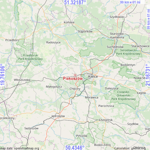
Piekoszów GPS coordinates[2]
50° 52' 49.26" North, 20° 27' 51.048" East
| Map corner | latitude | longitude |
|---|---|---|
| Upper-left | 51.32187°, | 19.76106° |
| Center: | 50.88035°, | 20.46418° |
| Lower-right: | 50.4346°, | 21.16731° |
| Map W x H: | 98.7×98.7 km | = 61.3×61.3mi |
| max Lat: | 54.83135° ⇑58.3% North |
| Piekoszów: | 50.88035° |
| min Lat: | ⇓41.7% South 49.21328° |
| min Long | Piekoszów | max Long |
| 14.20249° | 20.46418° | 24.03723° |
| W 64.6%⇐ | ⇒35.4% E |
Elevation
Elevation of Piekoszów is 276 m = 906 ft, and this is 84.6 m = 278 ft above average elevation for this country.
| Max E: |
974 m = 3196 ft | 17.9% |
| Piekoszów | 276 m 906 ft | |
| Avg. | 191.4 m = 628 ft | |
Min E: |
-3 m = -10 ft | 82.1% |
See also: Poland elevation on elevation.city.
Geographical zone
Piekoszów is located in North temperate zone (between Tropic of Cancer and the Arctic Circle). Distance of this North polar circle is 1743.8 km =1083.5 mi to North.| Distance of | km | miles | from Piekoszów |
|---|---|---|---|
| North Pole | 4349.7 | 2702.8 | to North |
| Arctic Circle | 1743.8 | 1083.5 | to North |
| Tropic Cancer | 3051.4 | 1896.1 | to South |
| Equator | 5657.4 | 3515.3 | to South |


Nearby cities:
15 places around Piekoszów: (largest is in red/bold)
• Brzeziny
14.2 km =8.8 mi,  147°
147°
• Chęciny
8.9 km =5.5 mi,  180°
180°
• Domaszowice
15.4 km =9.6 mi,  92°
92°
• Kielce
11.5 km =7.1 mi,  95°
95°
• Kostomłoty Drugie
8.8 km =5.5 mi,  53°
53°
• Kostomłoty Pierwsze
10.3 km =6.4 mi,  62°
62°
• Małogoszcz
16 km =9.9 mi,  241°
241°
• Miedziana Góra
8.7 km =5.4 mi,  44°
44°
• Mniów
14.7 km =9.1 mi,  5°
5°
• Oblęgórek
8.3 km =5.2 mi, 9°
• Osiedle-Nowiny
8.8 km =5.5 mi,  142°
142°
• Siedlce
15.4 km =9.6 mi,  172°
172°
• Strawczyn
7.5 km =4.7 mi,  336°
336°
• Zagnańsk
17.8 km =11.1 mi, 51°
• Łopuszno
16.8 km =10.4 mi,  296°
296°
Sources, notices
• [Note1] Compared only with cities in Poland existing in our database
• [Src1] Map data: © OpenStreetMap contributors (CC-BY-SA)
• [Src2] Other city data from geonames.org with taken over terms of usage.
• [Src3] Geographical zone / Annual Mean Temperature by Robert A. Rohde @ Wikipedia
