Miedziana Góra geodata
Miedziana Góra (Świętokrzyskie) is a seat of a third-order administrative division; located in Poland in Europe/Warsaw (GMT+2) time zone. With population of 2,317 people, there are 1318 cities with bigger population in this country. Compared to other cities in Poland, 56.7% of cities are located further ↑North; 65.7% of cities are located further ←West and 87.8% of cities have lower elevation than Miedziana Góra. Note1
Administrative division(s):
- Level 1: Świętokrzyskie
- Level 2: Powiat kielecki
- Level 3: Miedziana Góra


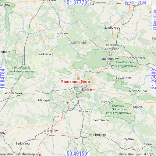
Miedziana Góra GPS coordinates[2]
50° 56' 12.48" North, 20° 33' 3.456" East
| Map corner | latitude | longitude |
|---|---|---|
| Upper-left | 51.37778°, | 19.84784° |
| Center: | 50.9368°, | 20.55096° |
| Lower-right: | 50.49159°, | 21.25409° |
| Map W x H: | 98.5×98.5 km | = 61.2×61.2mi |
| max Lat: | 54.83135° ⇑56.7% North |
| Miedziana Góra: | 50.9368° |
| min Lat: | ⇓43.3% South 49.21328° |
| min Long | Miedziana Góra | max Long |
| 14.20249° | 20.55096° | 24.03723° |
| W 65.7%⇐ | ⇒34.3% E |
Elevation
Elevation of Miedziana Góra is 307 m = 1007 ft, and this is 115.6 m = 379 ft above average elevation for this country.
| Max E: |
974 m = 3196 ft | 12.2% |
| Miedziana Góra | 307 m 1007 ft | |
| Avg. | 191.4 m = 628 ft | |
Min E: |
-3 m = -10 ft | 87.8% |
See also: Poland elevation on elevation.city.
Geographical zone
Miedziana Góra is located in North temperate zone (between Tropic of Cancer and the Arctic Circle). Distance of this North polar circle is 1737.5 km =1079.6 mi to North.| Distance of | km | miles | from Miedziana Góra |
|---|---|---|---|
| North Pole | 4343.4 | 2698.9 | to North |
| Arctic Circle | 1737.5 | 1079.6 | to North |
| Tropic Cancer | 3057.7 | 1900 | to South |
| Equator | 5663.6 | 3519.2 | to South |


Nearby cities:
15 places around Miedziana Góra: (largest is in red/bold)
• Chęciny
16.4 km =10.2 mi,  202°
202°
• Domaszowice
11.5 km =7.1 mi,  126°
126°
• Gózd
15.9 km =9.9 mi,  70°
70°
• Kaniów
9.6 km =6 mi,  55°
55°
• Kielce
9.1 km =5.7 mi,  144°
144°
• Kostomłoty Drugie
1.5 km =0.9 mi, 137°
• Kostomłoty Pierwsze
3.4 km =2.1 mi,  116°
116°
• Masłów
12.7 km =7.9 mi,  108°
108°
• Mniów
9.6 km =6 mi,  330°
330°
• Oblęgórek
5.1 km =3.2 mi,  291°
291°
• Osiedle-Nowiny
13.3 km =8.3 mi,  182°
182°
• Piekoszów
8.7 km =5.4 mi,  224°
224°
• Smyków
15.9 km =9.9 mi,  318°
318°
• Strawczyn
9.1 km =5.7 mi,  273°
273°
• Zagnańsk
9.2 km =5.7 mi, 58°
Sources, notices
• [Note1] Compared only with cities in Poland existing in our database
• [Src1] Map data: © OpenStreetMap contributors (CC-BY-SA)
• [Src2] Other city data from geonames.org with taken over terms of usage.
• [Src3] Geographical zone / Annual Mean Temperature by Robert A. Rohde @ Wikipedia
